In construction and operations, virtually all stakeholders across every industry agree on the value of accurate, digital “visualizations” of job sites. But for those who work in the retail and multi-site space, several unique frustrations make certain technologies—including intuitive, self-performed site surveying—particularly beneficial.
In this article, we’ll touch on three of the biggest challenges faced by retail and multi-site project managers and how these stakeholders use tools like reality mapping to overcome them. These pain points are:
1. Job site imagery shared with executives is usually incomplete
Since many construction executives rely on regional construction managers or project managers to monitor construction progress, stakeholders in the corporate setting rarely get a chance to see a store or site mid-build or refurbishment. Instead, these executives often review images or videos taken by regional managers using smartphones.
Unfortunately, a few dozen images or a couple of videos cannot accurately capture the entirety of a job site. Invariably, certain chunks of the site or store will be left out of the footage. And even when companies have invested in stationary webcams for on-demand look-ins at store progress, insight remains limited. After all, these “live feeds” show only the portion of the store visible from behind the web camera’s lens.
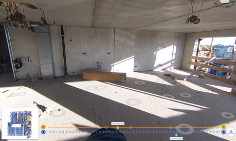
For project managers that want to provide complete transparency to executives, owners, and owner representatives, on-location site surveys can be rapidly and easily conducted with little more than a smartphone or 360 camera. In about 15 minutes, a project manager (or any other on-site employee) can walk the store, capture all footage, then sit back as a reality mapping engine transforms the data into an accurate, measurable duplication of the store.
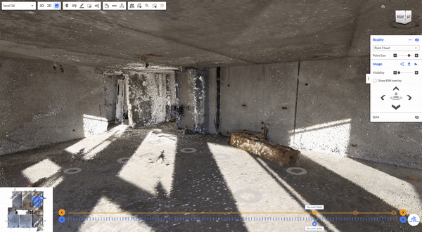
Suddenly, PMs can offer executives complete remote viewing sessions of every job site in their portfolio. These site surveys, which produce both 2D floor plans and 3D models of the store, can then be overlaid with design drawings and original plans for error detection, visual progress monitoring, coordination with design teams, and more.
Related: Remote Quality Control: The Secret to Avoiding Costly Rework
2. Waiting for site survey technicians slows down the remodeling process
Many companies in the retail and multi-site space rely on expert, turnkey survey providers to travel to a given store and survey the site with a Matterport scanner. This often causes not one but two problems for project managers and the companies they represent:
- It can take weeks to schedule the site survey technician, which further delays the timeline for reviewing current conditions drawings, determining the design details of the renovation, submitting plans to the city, and more.
- Once scheduled, the scan itself can take several hours, leading to business disruption and profit loss.
To combat this, more and more project managers are opting to “self-perform” site surveys. These surveys can be conducted immediately using inexpensive, everyday devices such as smartphones and 360 cameras, and essentially anyone on the job site can capture the footage. A regularly-sized store takes about 15 minutes to capture and gives stakeholders virtually the same information as a three-hour-long, professional Matterport scan—no weeks-long wait required.
With current condition drawings available soon after a site survey is self-performed, project managers can then rapidly coordinate with designers so that remodel plans can be finalized, overlaid onto 2D floor plans, approved by the company, and permitted by the city.
Related: How to Choose the Right Tool for a Site Survey
3. It’s virtually impossible to visit every store and perform thorough, timely error detection
Many construction or project managers are responsible for a portfolio of stores in one region, often but not always within driving distance of each other. But even PMs with the most conveniently-located map of stores find themselves constantly on the road. And for PMs with even more challenging territories, weeks of travel may be required.
But when on-site employees are using self-performed site survey technology (also known as reality capture and reality mapping technology) to document every inch of the store, PMs (and other stakeholders) do not need to physically travel to the job site to conduct walkthroughs, perform visual quality assurance and quality control, conduct facility condition assessments, look for problems with fixture placement, measure for signage, and so on.
Since the most advanced construction visualization software allows users to overlay plans and design atop site surveys, error detection can be performed regularly, making it easier for all stakeholders to compare planned fixture placement to actual fixture placement. Once errors are identified, PMs (or off-site stakeholders) can issue time and money-saving directives right away.
For the most accurate progress monitoring, many project managers perform a 15-minute capture of a store every time they visit the site, or ask an on-site representative to capture footage once a week. This creates a current visualization of the store while also generating a timestamped archive of construction or renovation. Months or even years down the road, PMs or other stakeholders can instantly turn back the clock on construction to answer questions, prepare for future refreshes, or even hand over the store to a new tenant.
Related: How Remote Construction Monitoring is Helping Build Sweden’s Tallest Office Tower
About Reconstruct
Reconstruct has set the gold standard for quick, intuitive, and self-performed site surveys across the construction industry. Reconstruct’s reality mapping engines make it easy for retail and multi-site stakeholders to turn footage captured on virtually any device (including smartphones and 360 cameras) into precise, measurable 2D drawings and 3D models. These assets, which are available to users via Reconstruct’s Visual Command Center, optimize remote project monitoring, design and planning processes, error detection, and facilities, maintenance, and repair coordination.
With Reconstruct, project managers can optimize oversight of their portfolio while drastically reducing the travel time, expense, and intrusiveness of their work. With remote progress monitoring, these PMs can inspect all stores, make informed decisions about design and next steps, and answer every last question from on-site teams and corporate executives in a single afternoon—no travel required.

.png)
.gif)