Typically, when we discuss the virtual and immersive asset utilized by construction, inspection, and engineering stakeholders to remotely “walk” a job site, we use the terminology “digital twin for construction” or simply “digital twin.” However, in the retail and multi-site space, such assets are typically called site surveys or 3D site surveys.
In this article, we will define a site survey in construction, walk through the easiest way to create one using reality mapping technology, and how these site surveys benefit different stakeholders, including on-site contractors, regional construction managers, and off-site corporate executives.
What is a site survey for construction?
In general, a site survey for construction is a record of an on-site inspection that helps stakeholders define the dimensions, locations, and other key details of a property.
Often, in retail and multi-site construction, construction sets out to renovate or “improve” an existing job site. For example, a coffee shop may take over a shuttered gas station, or a former fast food locale may be turned into a quick-service restaurant.
Regardless of the renovation details, stakeholders want to get construction started as soon as possible, and that process begins with a detailed and accurate site survey of the property’s current conditions. This asset can be created with a laser scanner or even drawn by an architect, but there is another way to create a site survey: with reality mapping software.
Using reality mapping software to create a site survey
In the past, retail and multi-site stakeholders may have relied on contracted experts to capture the current conditions of the job site. This process, including the waiting period for an expert’s schedule to open up, could take weeks, ultimately slowing down construction and pushing back a store's opening, which in turn impedes an organization’s ability to generate revenue.
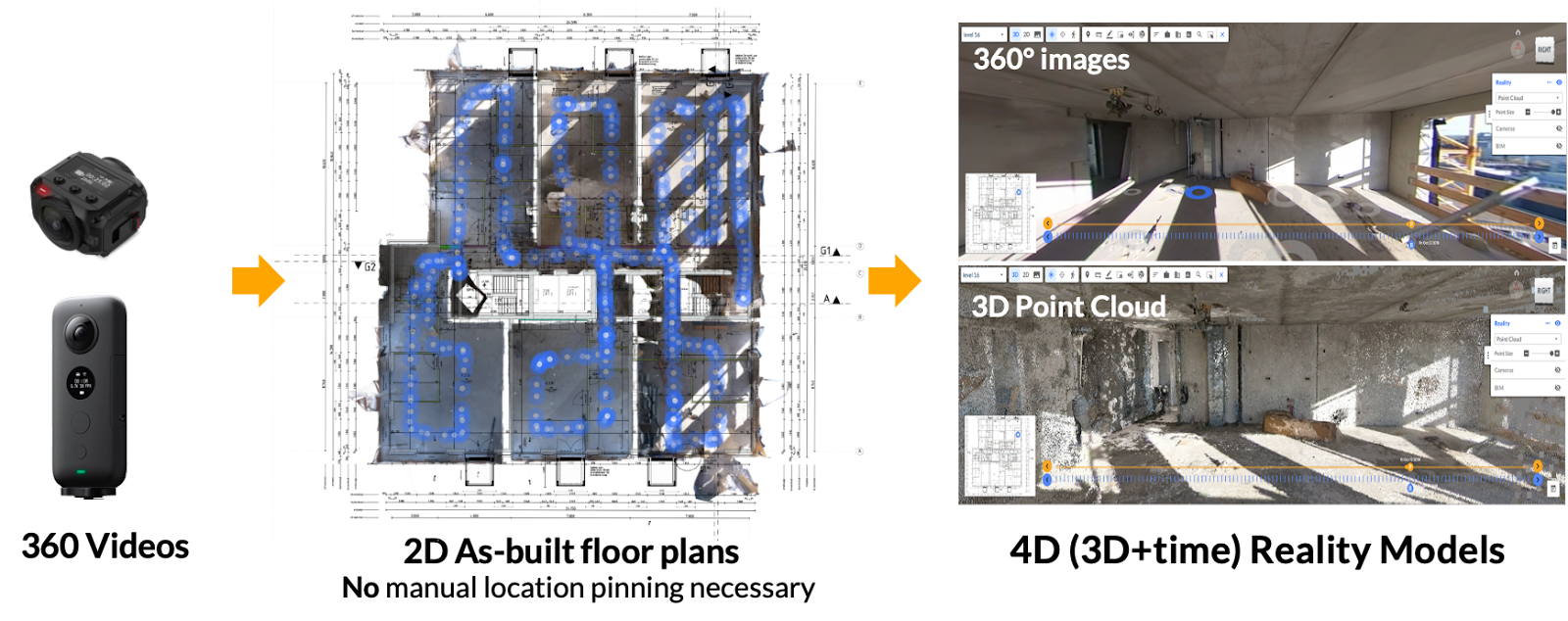
In an industry where time is money, the advent of intuitive reality mapping software has never been more vital. With the right photogrammetry engine, on-site personnel can rapidly capture a property's current conditions using devices as simple and inexpensive as a smartphone or a 360 camera. A drone, too, can also be utilized for exterior shots when necessary. However, since most retail and multi-site locations tend to be minor, this step is often unnecessary.
A 360 camera, for example, captures panoramic images of the job site at a rate of 1,000 square feet per minute. That means a gas station-sized property can be completely captured within 10 or 15 minutes. The footage is then fed to that photogrammetry engine. Footage can be blended from various sources, including 360 cameras, smartphones, and drones, to create one single source of project truth that reflects the current conditions of the property.
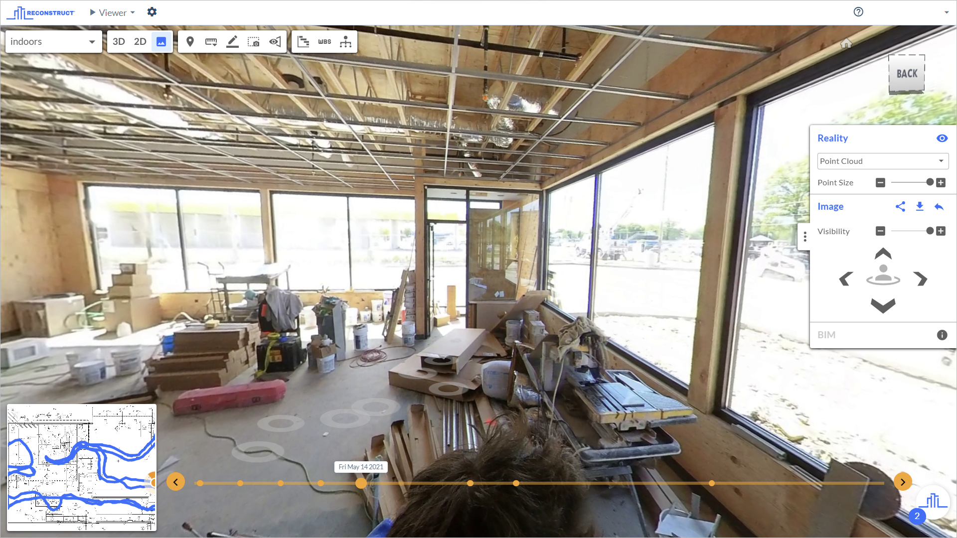
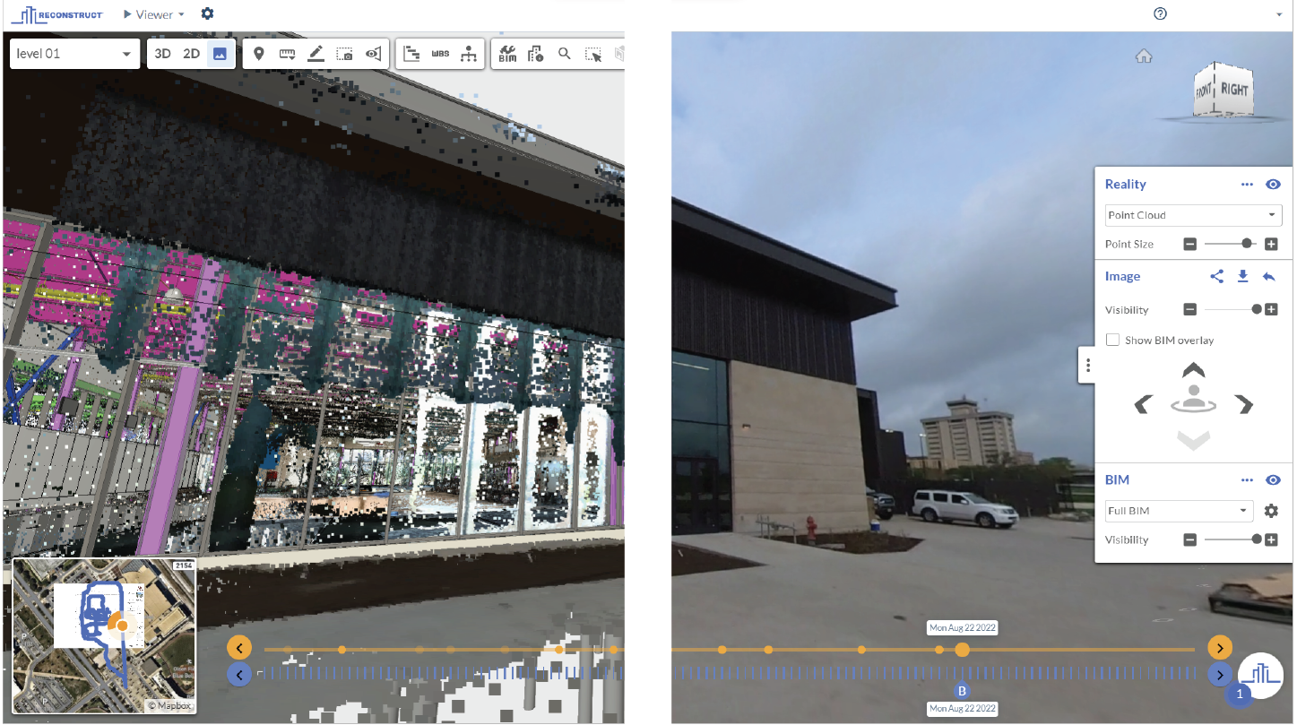
This site survey is automatically pinned in space and time for the most holistic and accurate digital twin possible. Moreover, data is provided in the form of a 3D immersive walkthrough and automatic 2D floor plans.
Once these assets are prepared, stakeholders, both on-site and remote, can utilize the site survey for a variety of use cases–and unlock a whole host of benefits right away.
Benefits of using reality mapping for site surveys
As previously mentioned, there are numerous benefits of utilizing reality mapping software to generate construction site surveys of a retail store or site. Many have already been covered in this article but are worth mentioning again. Here are the top five:
1. Anyone can perform reality capture and quickly
As noted in the previous section, one of the chief benefits of implementing a reality mapping strategy for retail and multi-site stakeholders is how fast and easy site surveys can be performed. Instead of losing time and money while waiting for an expert to capture current conditions, virtually anyone on the job site can rapidly perform reality capture and produce a digital twin the same day.
Again, this capture can be fully performed with everyday and affordable devices.
2. Portfolio managers, construction executives, and other stakeholders can reduce travel
In many multi-site operations, a single portfolio manager is responsible for sometimes more than a dozen sites and stores. If that stakeholder must travel from site to site to sign off on work, construction can be severely slowed down. Reality mapping software allows these stakeholders to walk job sites remotely whenever necessary, enabling faster construction while reducing not only travel but also travel-related expenses and fatigue.
In other words, site assessments that may have previously required several weeks of travel can now be completed in a single afternoon–without that point person ever leaving their desk.
3. Reality-captured site surveys are highly accurate
One of the chief benefits of cutting-edge reality mapping software is that the digital twins it produces are not only immersive and time-stamped but also completely measurable.
That means that, beyond offering remote stakeholders an accurate glimpse into a site's current conditions, these digital twins also enable off-site stakeholders to confidently measure all aspects of the project.
4. Plans and improvements can be overlaid against reality data
Another benefit of using reality mapping for a site survey is that, with the click of a button, stakeholders can also overlay plans, drawings, and even ideas for renovations and designs against current site conditions.
This is excellent for imagining the future look and feel of a job site and expediting the permitting process.
5. Reality mapping can be used even after construction for a variety of purposes
Even when a site survey of current conditions before construction begins is no longer necessary, retail and multi-site stakeholders often find that the ability to rapidly capture a job site at any given time has distinct benefits. This is especially true for corporate stakeholders and regional portfolio managers who want to keep their eye on job sites without committing to a grueling travel schedule, even months and years after construction is complete.
About Reconstruct
Reconstruct has set the standard for digital twins and site surveys across various industries, including the retail and multi-site space. To learn more about Reconstruct and to see your store or site as a digital twin, schedule a free demo today.