How reality mapping can fill in the gaps of 4D BIM
In construction, 4D BIM incorporates time-based scheduling details with traditional 3D BIM, clarifying exactly when tasks will be completed or installed along the construction timeline. And while 4D BIM has been shown to improve project understanding, optimize scheduling, improve clash detection, and enhance communication, most construction stakeholders cannot or will not use 4D BIM for every aspect of construction.
In this article, we'll zero in on how combining time and 3D reality mapping for “4D reality” offers many of the same benefits as 4D BIM for aspects of a construction project that typically go unmodeled. By blending the reality of a job site with future planning, construction stakeholders can instantly understand current conditions and how they may impact future installations. They can also use the resulting digital twins for better schedule coordination, constructability and safety analysis of the upcoming work, site access, layout, and monitoring work-in-place against work-in-progress or planned work.
Key takeaways:
- While 4D BIM is an excellent way to model the final design of a structure, resource limitations usually prevent the modeling of most job sites in temporary states along the construction timeline.
- When combined with time and schedule, 3D reality mapping offers a “4D reality” of a job site at any stage. This allows stakeholders to understand current conditions and how those might affect construction and schedule down the road.
- At its best, reality mapping technology is rapid and intuitive, and can be conducted using a smartphone, 360 camera, or drone. Footage is automatically pinned in space and over time, providing an accurate, timestamped, and completely measurable as-built model of a job site whenever 4D BIM is not required, practical, or possible.
- 4D reality significantly expedites the creation of usable 4D BIM models because you only need to focus on tying in BIM elements against scheduled activities without worrying about modeling temporary structures, details not shown in BIM, and keeping 4D models up to date.
4D reality mapping models the temporary equipment, materials, and works 4D BIM excludes
Typically, 4D BIM models reflect the final design of a structure. They do not show the temporary materials and temporary works heavily involved in construction. Additionally, a high level of effort is required to create comprehensive 4D models, so it's not always feasible or necessary to model everything using 4D BIM.
This is especially true now that advances in reality mapping technology have made it easier than ever before to turn job site imagery into four-dimensional, timestamped representations of construction projects at every stage of progress.
Without spending resources on highly intricate, expertly-developed 4D BIM, organizations can simply capture the reality of their job site using everyday devices such as a smartphone or 360 camera, then ask a photogrammetry engine to generate as-is models of the project at any time along the construction timeline—including those key-but-temporary stages that would never be modeled with 4D BIM.
And because this low-impact, low-lift technology can be utilized whenever by whomever, it's that much simpler to create 4D visualizations of temporary materials, including cranes, scaffolding, steel beams, piles of dirt, temporary structures, roadways, and signage. These types of items rarely appear on 4D BIM, but visualizing them can significantly impact a field team's ability to coordinate a more informed and realistic approach to next steps and complete construction in a safe, timely manner.
Features of 4D reality mapping
The following features are some key offerings of 4D reality mapping that can reduce or eliminate the need for higher-effort, higher-expense 4D BIM.
- The ability to bring in imagery in 2D as an orthophoto.
- The ability to bring 360- and drone-captured images into the 3D domain and navigate around them.
- The ability to measure all models precisely.
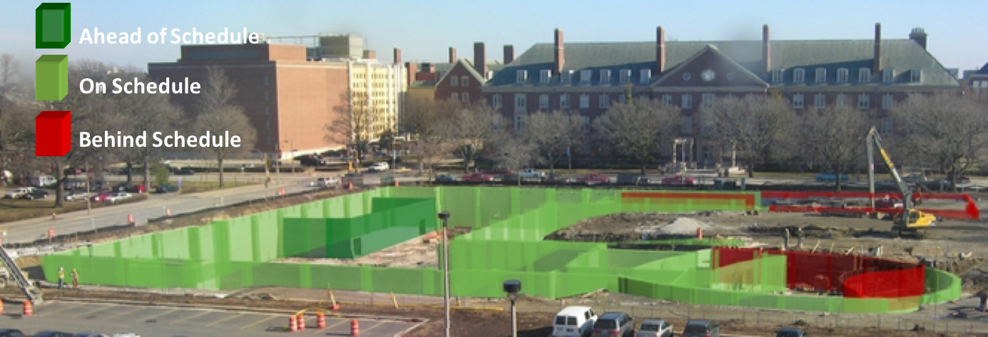
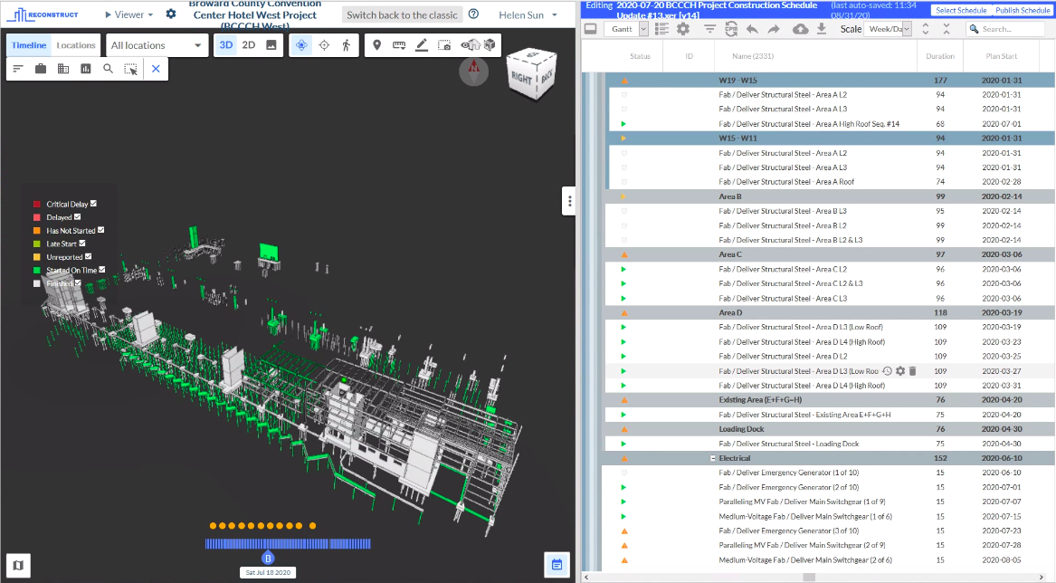
Also notable is the ability to fully overlay 4D BIM against 4D reality, so at any moment, you can visualize the digital version of the plan against the “digital twin” of what’s actually on site.
Benefits of 4D reality mapping
One key benefit of using reality mapping for temporary structures and materials? You don't have to model all these temporary works because you can rely on reality-captured imagery instead. Rather than virtually modeling where steel is located for one week, you can photograph where the steel is currently located and automatically integrate that footage into your reality model.
Another significant benefit to 4D reality modeling is truth in reporting. Typically, field reporting offers actual dates and percentages of tasks and project completion. But sometimes, reporting against schedules can be ambiguous. Numbers do not always paint the complete picture.
Perhaps a report indicates that a particular task is 50% or 60% complete. What does that actually mean? What work has actually been completed? You’d have to walk the site to find out—or you can use a 4D reality model to answer questions only a walkthrough could’ve addressed in the past.
When visual progress monitoring and reporting are accompanied by completely measurable, timestamped visuals that can be compared against schedule and plans, any update to the schedule will be validated through imagery. This allows off-site stakeholders to not only visually confirm a task is 50% complete but understand what the percentage means. Is it the west half or the east half? The simpler work or the more complex installation? With reality mapping, stakeholders can see for themselves without leaving their desks.
Reality mapping can also expedite the processing of contractor pay apps so contractors can lower commonly occurring delays without maxing out their credit lines or taking out more loans. This reduces the chances of project delays, disputes over the quality of completed work, scope changes, and contract disputes.
All these benefits are unlocked by “temporary” digital twins that serve as a single source of truth for all stakeholders, both on-site and remote.
Related: Remote Construction Monitoring: The Key To Building Sweden's Tallest Office Tower
About Reconstruct
Reconstruct is the leading provider of reality mapping and digital twin-driven project control technology. Using virtually any device, any team member on any job site can conduct rapid reality capture, then ask Reconstruct to transform footage into measurable, as-built floorplans and immersive models. Once generated, these reality models are integrated with 2D design, BIM, and schedule to empower all teams with a single source of truth that can be used to improve project outcomes while slashing the time and money spent on constant travel to the job site and 4D BIM generation.
To learn more about how photogrammetry can help your team fill the gaps of 4D BIM at any phase of construction, contact us or schedule a personalized demo.

.png)
.png)