

Our approach is to use both the original images and the reconstructed points directly to perform measurement. Our recent user study shows that measurement using images overlaid on 3D point clouds with Reconstruct's viewer provides the best combination of precision and user experience, improving the accuracy by a factor of 4 vs. using point clouds alone and a factor of 2 vs. using a mesh.
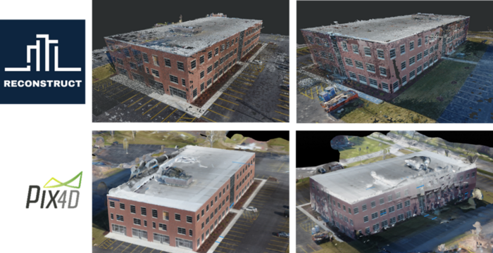
Using the same set of photos (taken by drone), we created 3D models using Reconstruct's engine and, for comparison, Pix4D's engine. The photos were taken at a height of 100 ft and, for lateral shots, distance of 30 ft from the building. The resulting models are shown below, using screenshots from the Reconstruct and Pix4D viewers.
We asked five users to perform several measurements on the ground and on the building walls using Reconstruct's 3D point cloud directly, images overlaid on the 3D point cloud, and Pix4D's online textured 3D mesh and measurement tools. We determined the true values by taking measurements directly in the scene.

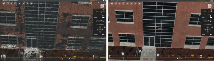
As expected, users report that overlaying the image makes it much easier to perform measurements. But we were surprised that using the image overlay improved accuracy compared to point cloud only by a factor of four, from an average error of 4" to 1" per measurement! The interface for 3D measurement is just as important as the precision of the 3D model for obtaining accurate measurements. This is an important observation because most reality capture services emphasize the theoretical limits of 3D point precision, rather than the precision of measurements obtained by users.
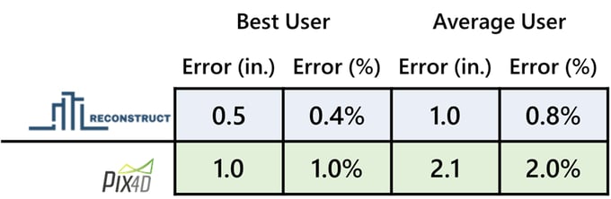
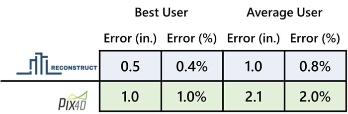
In summary, the accuracy of your measurements from 3D models depends on both the interface and the precision of the model. Mesh models provide textured surfaces that are easy to interpret, but often oversimplify the surface or contain errors. Point clouds, by themselves, lack the high resolution of original images. Only Reconstruct provides image overlay in a web-based system to provide maximum detail and precision, making measurement simpler and more accurate.
Getting Started with Reconstruct
Want to learn how Reconstruct can help your project? Visit www.reconstructinc.com to start your free trial or request a consultation with one of our team members.
Related Posts
2D & 3D Design Integration with Construction Reality Mapping
Discover the many benefits of integrating 2D and 3D design and drawings with accurate, measurable 2D floor plans and 3D models of a construction project.
The History of 3D Reality Mapping with 360 Cameras
Reconstruct released the reality mapping technology needed to 3D model job sites from 360 cameras in 20156, transforming remote project monitoring.
How Reality Mapping Can Fill in the Gaps of 4D BIM
4D BIM is great for modeling a structure’s final design. For temporary conditions, fast and intuitive 4D reality mapping fills in the gaps.