New technology allows construction stakeholders to overlay 2D and 3D designs and plans atop a “digital twin” of a real-world asset. By visualizing design drawings and plans against a virtual job site, it's much easier to compare what's been built to what's been planned, then identify and resolve any detected issues quickly.
This article will discuss how 2D and 3D designs are integrated with reality mapping technology to unlock valuable benefits for virtually every stakeholder in the construction industry.
Key takeaways
- Overlaying design drawings or BIM against as-built 2D floor plans and 3D models instantly reveals what's been built on a job site versus what should be there.
- These design-vs.-reality visuals help stakeholders visualize problems swiftly, then take quick action to minimize rework, stay on schedule, and improve safety and design outcomes.
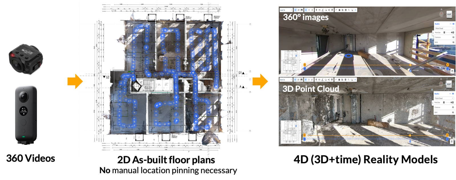
- 2D and 3D design integration atop “as-builts” is enabled by reality mapping technology. It is now possible to create as-built 2D floor plans and 3D models by asking any on-site employee to quickly capture reality data with a device as simple as a smartphone or 360 camera.
How are 2D and 3D designs integrated with reality mapping models in construction?
In construction, 2D and 3D design integration refers to integrating 2D drawings and 3D models with reality data captured on a job site. This reality data can be captured by virtually any camera-equipped device, which can be operated by nearly any employee on a job site—no expertise required. This video or image footage can then be fed to a photogrammetry engine and transformed into a 3D digital twin of the asset. 2D, precise floor plans can also be generated.
Once this digital twin is ready to view, certain software allows stakeholders to overlay virtually any design drawing or plan atop the floor plan or model. Below are some of the most valuable benefits of integrating design with reality mapping technology:
1. Enhanced visualization
When designs and plans are overlaid against the reality of a virtual job site, the visualization unlocks benefits for virtually every stakeholder involved in a construction project. Instantly, remote and on-site team members can:
- better communicate design
- perform informed project monitoring
- swiftly identify missteps and installation errors
- coordinate next steps
- compare design against reality
2. Smarter design coordination
By integrating all sorts of design drawings and plans—including BIM—against reality data, remote construction stakeholders more easily communicate design to field teams, then efficiently coordinate who does what work by reviewing the most up-to-date version of the project and comparing it against the latest design.
This leads to faster, higher quality, and more accurate installations, even for projects whose designers and architects are half a world away.
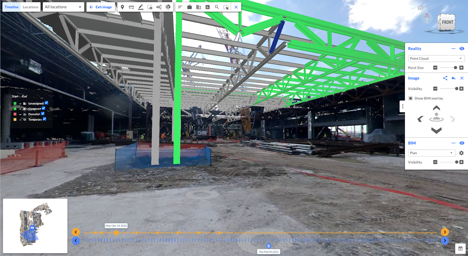
3. Swifter clash detection
By integrating specific coordinated models and drawings against a structure’s digital twin, stakeholders also perform more intelligent clash detection. This is especially true for 3D integrations, where potential clashes between different elements, such as pipes and beams, can be identified against the reality of a project as built… not the version documented as an as-built, years ago.
Some photogrammetry engines, including Reconstruct, offer 4D scheduling and 4D BIM for stakeholders who require additional, time-lapsed clash detection.
4. Improved remote project monitoring
Design integration with reality mapping technology also allows for effective visual quality assurance and quality control. Using 2D and 3D drawings and plans, stakeholders frequently review what's been built against what’s been designed, complete RFI documentation, conduct safety inspections, and prepare punch lists without ever stepping foot on the job site.
Related: How remote construction monitoring is helping build Sweden's tallest office tower
5. Faster error detection
Another reason construction, inspection, and engineering stakeholders turn to reality mapping technology is for improved and more expedient error detection. Because geo-referenced reality capture can be performed by nearly any employee on the job site, companies with even reduced budgets and resources can create as-built 2D floor plans and 3D models of their job sites. Next, all stakeholders must do is lay the relevant design drawing or plan atop the reality data.
Reconstruct’s Visual Command Center, for example, then allows stakeholders to pin concerns on problems exactly where they've been visualized on the digital twin. From there, team members can either resolve the issue via a standard collaboration tool or urgently message on-site stakeholders using a higher-priority, rapid messaging system.
These features lead to not only faster and more precise error detection but also an automatically documented and inherently faster strategy for resolving such problems.
Related: How to choose the right reality capture tool for a specific job
6. Optimized communication between remote teams
As discussed above, the best photogrammetry engines enable the integration of 2D and 3D design and empower stakeholders to swiftly communicate about whatever has been visualized. Because all stakeholders view one digital twin as a single source of truth, then overlay the same design atop that reality data, even teams who usually don't see eye to eye can come together to identify problems and resolve them quickly.
This is a particularly useful tool for many across the construction and inspection industries, including stakeholders who rarely travel to the job site but are heavily invested in the project's safe, high-quality, on-time, and at-budget completion.
In other use cases, 2D and 3D design integration can transform a quick site survey of a former gas station into a total visualization of refurbishment plans. Such drawings can expedite corporate approval, streamline the permitting process, and align field teams on the next steps without excessive and expensive travel.
Related: 3 Construction Pain Points for Retail & Multi-Site Project Managers
7. Significant cost and time savings
Finally, as mentioned above, many stakeholders find that by integrating design with reality data, more mistakes are avoided, and any errors made are fixed sooner. This often leads to significant savings in both cost and time, including those associated with rework.
About Reconstruct
Reconstruct is a pioneer of reality mapping and photogrammetry technology, empowering on-site and remote construction stakeholders to visualize their projects like never before. This includes integrating virtually any design drawing or BIM with easily-captured reality data to truly see what’s been built versus what was planned.