
Using smartphones for 3D reality mapping and surveys during construction
One of the features that makes Reconstruct’s reality mapping engine so unique is its ability to interpret and blend reality data captured on virtually every type of device. From smartphones to 360 cameras to drones to laser scanners, Reconstruct’s technology automatically pins footage in space and over time, piecing together whatever pictures and videos you’ve captured into one immersive digital twin for construction.
During our groundbreaking experiment at the Oracle Lab in Chicago, we worked alongside our collaborators to determine which reality capture tools were best for various use cases. In this article, we’ll zero in on the benefits of using a smartphone for geo-referenced reality capture.
Key takeaways
- The smartphone camera already in your pocket is often the perfect choice for quickly capturing the details of certain elements of a construction project, including mapping recent installations of underground pipes and utilities, quality control and inspection of rebar cages and their embedments, conduits, etc., before placement of concrete, in-wall inspections, and mapping under-ceiling MEP modules.
- Smartphone cameras yield images with dense 3D point clouds and 2D floor plans (or 2D under-ceiling orthophotos), and those extra point clouds and 2D reality maps provide even better clarity and measurability.
- While a 360 camera is perfect for rapidly capturing a panoramic view of a job site, complementing this footage with key high-resolution images provides stakeholders additional accuracy and visibility where it matters.
Smartphones are affordable—and always handy for reality capture.
Just about everyone on your active job site has a smartphone. By selecting a reality mapping engine that accepts smartphone data and expertly blends that footage with reality data captured using other types of hardware, you’re much more likely to receive thorough and frequent updates to your digital twin.
Smartphones are readily available and can be used alongside 360 cameras to provide virtually all the footage needed for visual progress monitoring, visual quality assurance and quality control, and even facility condition assessments, physical asset inspections, and site surveys. These solutions offer complementary reality mapping and documentation capabilities to those of high-precision laser scanners and photo-realistic Matterport walkthroughs.
Most importantly, all types of footage can be integrated against one another over a project timeline so that project stakeholders can leverage a true Visual Command Center.
Related: 10 Benefits of Visual Progress Monitoring for Construction Stakeholders
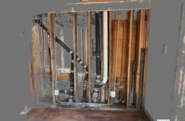
A measurable 3D point cloud model produced with a standard video taken by a smartphone for in-wall Inspection during the retrofit of an apartment building.
Smartphones excel at capturing the details of a construction site.
As mentioned above, many organizations utilize a combination of 360 capture and smartphone capture for regularly scheduled “capture walks.” As detailed in our guide to 360 cameras and capture, the 360 camera is perfect for rapidly recording uninterrupted panoramic images or videos of a job site.
For example, a 360-camera operator can walk a predetermined path of a construction site and capture reality from every angle without having to twist or turn the camera. This makes a 360 camera the perfect choice for quickly gathering contextual data. However, if there’s a desire to capture in-depth details for remote monitoring or inspection, a smartphone provides a clearer image and better measurability.
This is because smartphones typically have high-quality camera sensors compared to 360 cameras. These devices result in higher-density point clouds, which yield better 2D floor plans, orthophotos, and measurement capabilities.
Details frequently captured with smartphones can be useful for as-built documentation and inspection of:
- Detailed MEP systems
- In-ground/trenches of underground utilities
- Pre-pour inspections
- In-wall installations
In other words, smartphone capture allows remote stakeholders to not only sign off on work with confidence but also create a digital archive of what’s behind a wall or in a ceiling should questions arise. (This, in turn, allows a tenant, inspector, contractor, or any other stakeholder to review installation without the cost or destruction of demolition.)
What’s more, smartphones are also great for inspecting current conditions. For example, highly detailed, point cloud-rich images of a sidewalk outside a building can inform remote stakeholders whether the path is in good enough condition to remain ADA-compliant. If not, these inspectors can pin concerns directly onto visualized cracks, bumps, and crevices, then assign tasks to on-site teams until all issues are resolved.
Some of the top benefits of using smartphones for construction reality capture and mapping include:
- Democratized reality capture, which enables anyone on site to capture footage with any smartphone that has a camera.
- An end-to-end, automated process, from file upload to 3D reconstruction and alignment of assets against design.
- No need for special equipment like drones, laser scanners, 360 cameras, or LiDAR sensors on your phone.
- Higher-quality reconstruction than that derived from 360 cameras.
- Ease of use, as no special training is required.
Related: Remote Construction Monitoring: The Key to Building Sweden's Tallest Office Tower

3D mesh and point clouds from smartphone videos for pre-pour inspection of a concrete rebar spacing and placement of sleeves and boxout.
About Reconstruct
Reconstruct has set the gold standard for digital twins across the construction, inspection, and engineering industries. For nearly a decade, our technology has enabled organizations with budgets of every size to capture the reality of their job sites using any hardware they’d like, and then turn that data into measurable digital twins with our photogrammetry engine.
To learn more about our reality mapping solutions and find out what tools are best for your organization's next project, feel free to contact us or schedule a personalized demo today.
Related Posts
.png)
How to generate 3D point clouds from both 360 and drone reality capture
Blend indoor 360 video capture and outdoor drone capture for one integrated 3D reality mapping system.
Benefits of 3D Scanning in Construction
The benefits of 3D scanning in construction include improved remote quality control, virtual progress monitoring, and protection against liability claims.
Reality Capture & Reality Mapping for Construction Job Sites
Learn the difference between reality capture & reality mapping—& how reality mapping creates a precise, measurable, & immersive 3D version of your job site