
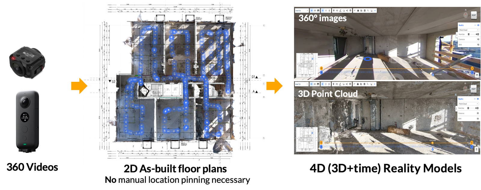
Reconstruct automatically converts your existing 360 video footage into measurable walkthroughs, 3D point clouds, and 2D as-built floor plans. These as-built representations can be overlaid with design in 2D and 3D in a web viewer, seamlessly allowing stakeholders to review “what is there” vs. “what should be there” on any project site, from anywhere in the world.
Many construction, inspection, and engineering stakeholders are already using 360 cameras to help them better record the visual conditions of buildings, bridges, and other physical assets. After all, 360 cameras are inexpensive, easy to use, and can rapidly capture job site footage at every angle. And since 360 capture is easy and intuitive enough for any team member to perform regularly, 360 cameras are frequently used for project monitoring, visual quality assurance and quality control during construction, and inspecting existing physical assets.
But most stakeholders aren’t getting enough out of their 360 capture efforts. A simple, as-designed floor plan with “pinned” 360 video frames isn’t as actionable as an in-person walkthrough, mainly because no measurement is possible from these walkthroughs. But using the 360 camera video footage you’ve already captured, the most cutting-edge reality mapping engines can create a digital twin of your job site that’s a virtual duplication of your job site, as-built.
You (or any other stakeholder) can then walk, measure, and inspect this single source or project truth from any 360 video frame…from anywhere, anytime. You can also download 3D point clouds, 2D as-built floor plans, or reflected ceiling planes automatically created by the best photogrammetry engine, then take them back into your design environment for building renovation, infrastructure retrofit, or brownfield projects.
This article will dive into the features and benefits of bringing your existing 360 videos to Reconstruct to transform that footage into a timestamped digital twin for construction.
Key Takeaways:
- Many reality capture providers only pin 360 video footage to floorplans instead of generating measurable walkthroughs of the job site and 3D point clouds. If you already use a 360 camera to capture project footage, it's never too late to transform that data into a digital twin of your job site that details construction progress over time.
- Reconstruct is the only reality mapping engine to create measurable walkthroughs, 3D point clouds, 2D floorplans, and reflected ceiling plans through 360 video alone. You can also feed Reconstruct footage taken from any other device, including a smartphone, drone, or laser scanner. It will automatically be blended into the digital twin.
- Instead of simply viewing footage as-is, Reconstruct creates an immersive, measurable duplication of your job site. The walkthrough can be shared with stakeholders anywhere via Reconstruct account or Reconstruct’s Project Snapshot tool.
- Once your digital twin is generated, you can also overlay 2D and 3D designs and compare what's there vs. what should be there.
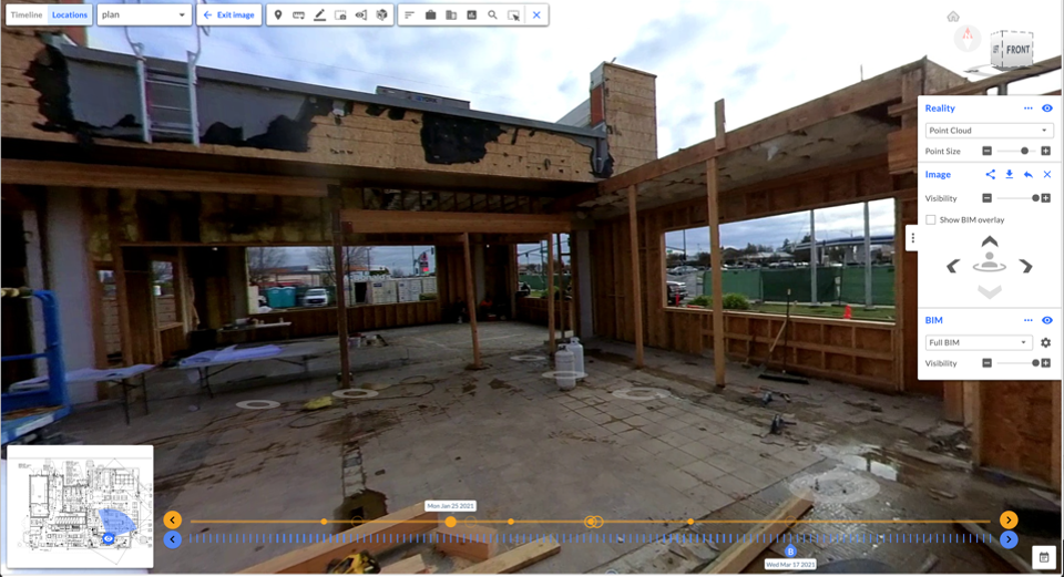
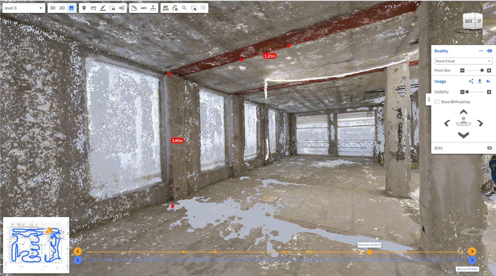
Left: A measurable 360 video frame pinned against a 2D floor plan; Right: A 3D point cloud created from this 360 video footage; creating the backbone of measurement tools shown in the left side image.
Turn existing 360 video capture into a measurable 3D walkthrough of your job site
If you’re simply reviewing as-is footage captured on your 360 camera or accessing it as-pinned to a floorplan, you’re leaving tons of data and actionable insights on the table. After all, 360 capture was meant to be immersive and an alternative to in-person walkthroughs for typical project inspections. In the absence of measurement capability, remote inspection is heavily handicapped as it may require going back to the site for additional inspections or field measurements.
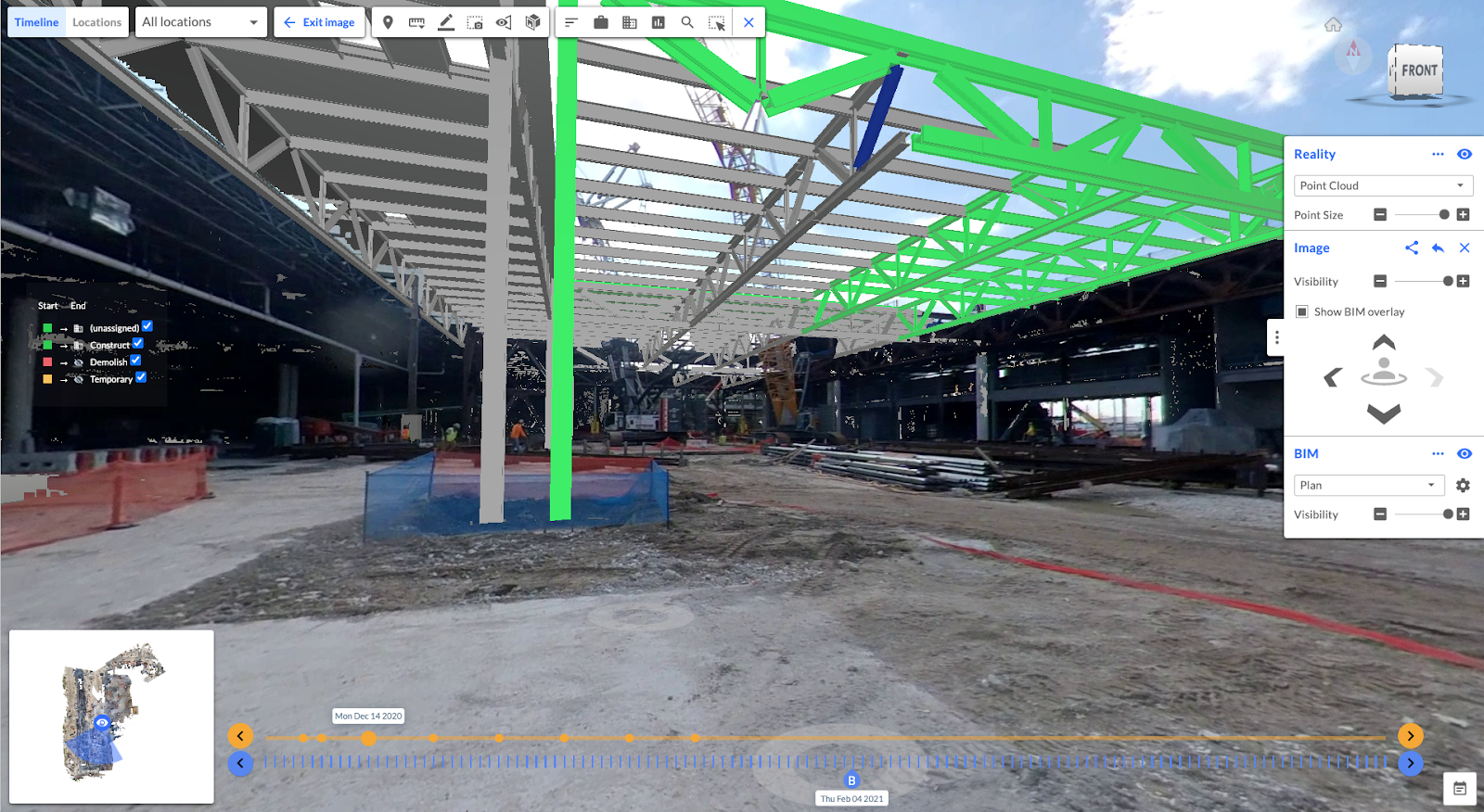
With the right photogrammetry engine, your 360 camera can perform geo-referenced reality capture that automatically pins every inch of job site footage into a digital twin of your asset in space and over time. You can also create, review, and download 3D point clouds, 2D as-built floor plans, and reflected ceiling plans directly created from these 360 videos. These deliverables can be imported into design or model coordination environments for various use cases. They can also be overlaid with 2D and 3D design, allowing owners, contractors, and designers to be on the same page as to what the design shows vs. what the reality of the as-built conditions looks like.
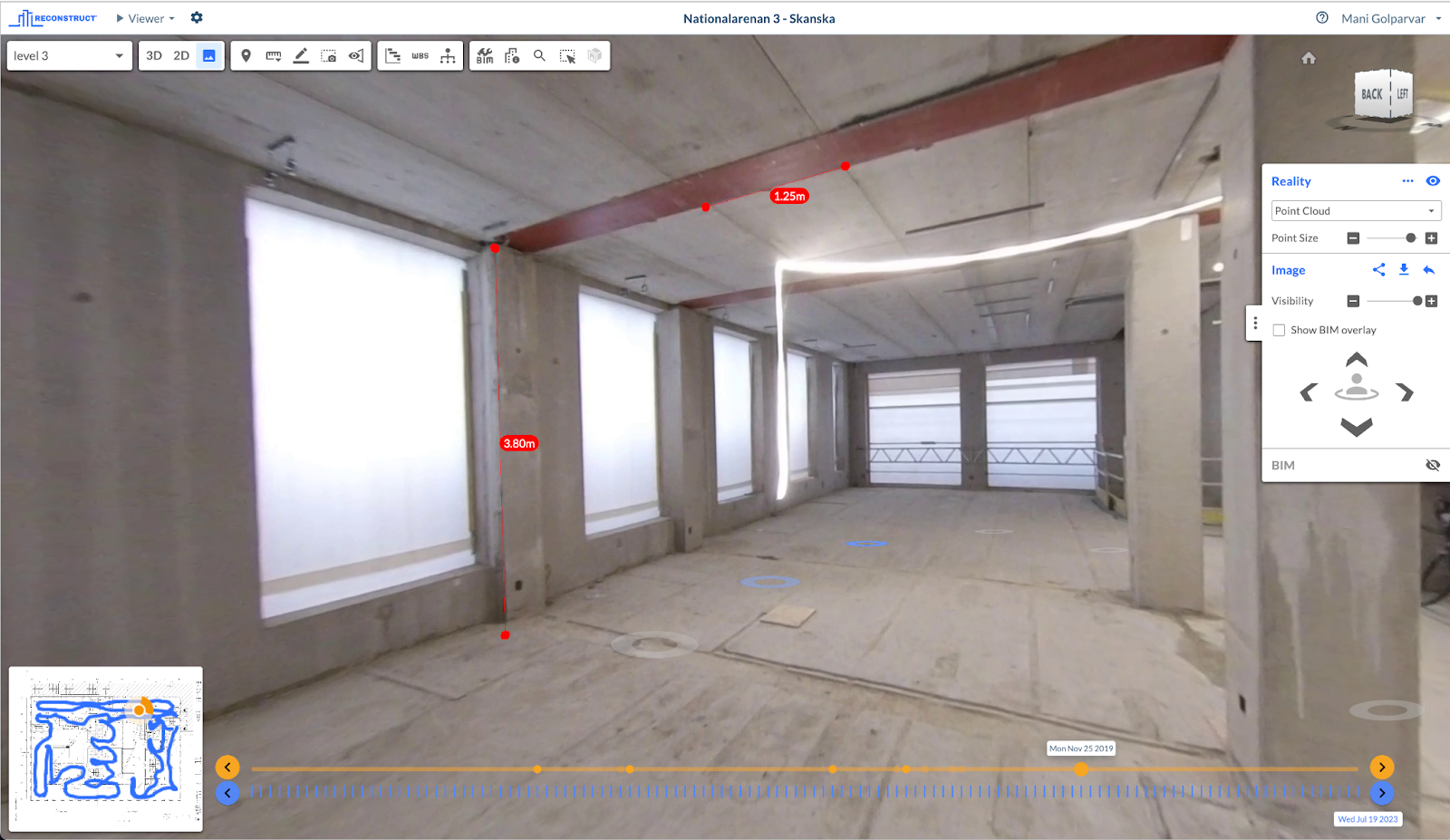
Suddenly, the disconnected footage you’ve taken of your project over the past weeks, months, or even years is transformed into a measurable virtual duplication of the job site as it stands today and as it appeared throughout past captures. Reconstruct is a true time machine for construction, allowing stakeholders halfway across the world to walk the job site as if they were really there. Remote stakeholders can measure details such as angles, lengths, surface areas, and volumes directly from 360 video footage, pin questions to visualized problems, immediately send work orders to field teams, and even overlay design and plans atop as-builts.
Moreover, only Reconstruct allows users to blend footage from any reality capture device. That means if you also captured footage of your job site using a drone, smartphone, Matterport, or laser scanner, Reconstruct can combine all that footage into one fluid, precise representation of the project. This all happens automatically. There’s no need to upload floor plans. The photogrammetry engine automatically knows when the capture was performed against other datasets and precisely where the footage was captured.
Related: Reality Mapping vs. Reality Capture
Compare what’s there vs. what should be there, both now and in the past
When your digital twin is ready within Reconstruct’s Visual Command Center, 3D point clouds, 2D floorplans, and reflected ceiling plans can be used in virtually every way imaginable. Many customers utilize their digital twins to compare what’s been built against what’s been planned. This is a quick way to rapidly perform frequent quality assurance and quality control without constant travel and walkthroughs.
By overlaying design and plans against what’s actually present on the job site, it’s much easier to detect potential or actual mistakes that could lead to costly rework and significant project delays. The more frequently stakeholders perform reality capture and the easier it is to visualize that data, the sooner and more easily such errors can be detected--and resolved.
This way, you can bring the best of two worlds of laser scanning and 360 camera-produced point clouds together: conducting laser scanning for project milestones and high-precision tasks, while relying on 3D point clouds and measurable views from 360 videos for daily or as-needed use, such as checking rebar spacing, embedments, conduits, and other day-to-day installations. With this hybrid approach, you can rest assured your team will have the same walkthrough and image-based measurement experience regardless of the tools used in the first place…all within one true and integrated web environment.
Moreover, stakeholders can easily “turn back time” and walk through their job site on a previous date. This allows stakeholders to confirm prior installations or see what’s behind a sealed wall or a slab of concrete without the delay or expense of demolition.
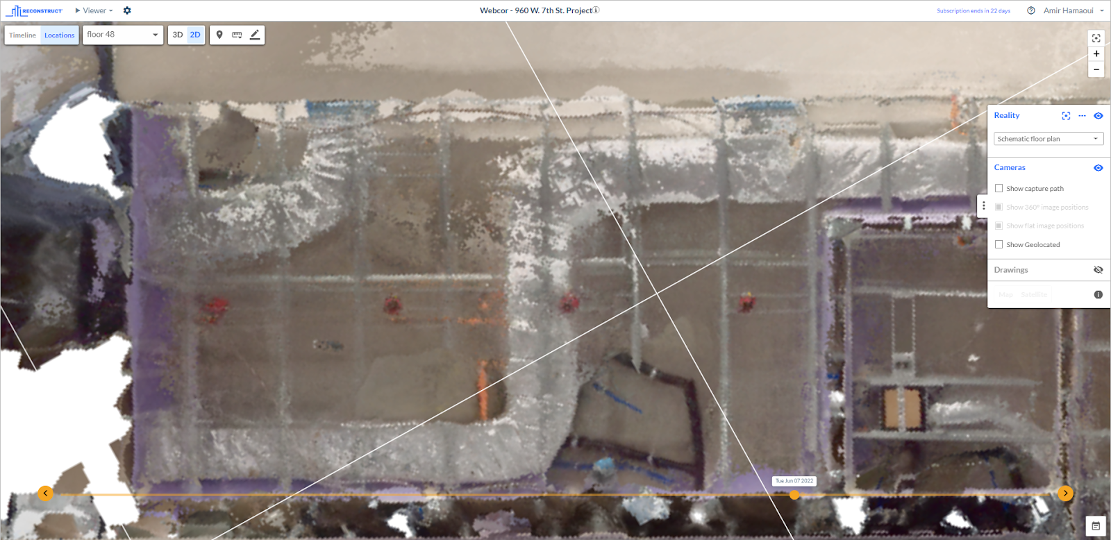
Existing 360 videos are automatically transformed into 3D point clouds and as-built reality floor plans. Next, using AI-driven techniques, these reality floor plans are aligned against 2D as-designed floor plans, offering a measurable street-view walkthrough experience with downloadable 3D point clouds, mesh models, as-built floor plans, and reflected as-built ceiling plans.
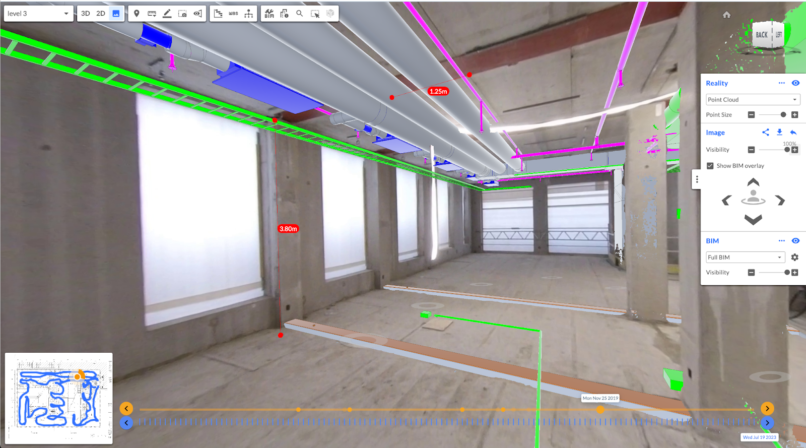
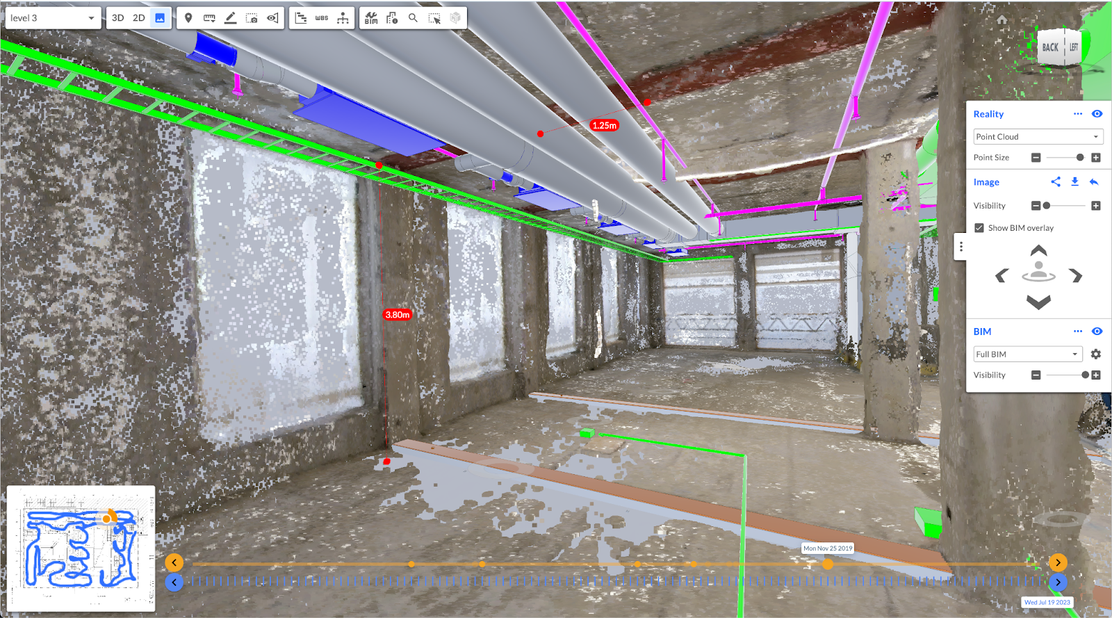
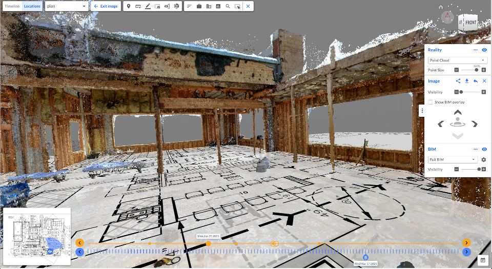
Top Left: Measurable 360 video footage; Top Right: Point cloud view of the same 360 video footage; Bottom Left: Point cloud of the 360 video footage overlaid with BIM; and Bottom Right: BIM overlaid on measurable 360 video footage.

Left: Reflected ceiling orthophoto; created from a 360 video; Right: 2D as-designed reflected ceiling drawing overlaid on the as-built ceiling orthophoto.
About Reconstruct
Reconstruct is the only photogrammetry engine that blends all footage from all types of hardware into one digital twin. The result? A single source of project truth that can be used by all stakeholders for various use cases, from facility condition assessments to quality control to liability protections.
Do you have existing 360 videos of your job site? If you want to see them transformed into 3D point clouds, 2D floor plans, and measurable walkthroughs of your construction portfolio, reach out to us for a personalized demonstration.
Related Posts
2D & 3D Design Integration with Construction Reality Mapping
Discover the many benefits of integrating 2D and 3D design and drawings with accurate, measurable 2D floor plans and 3D models of a construction project.
.gif)
Compare design against existing 360 and drone reality capture
Use existing reality capture data from 360 cameras, drones, and other devices to compare design and plans against what’s actually been constructed.
.png)
How to generate 3D point clouds from both 360 and drone reality capture
Blend indoor 360 video capture and outdoor drone capture for one integrated 3D reality mapping system.