

New advances in reality capture and reality mapping technologies can improve how construction project stakeholders—including owners, developers, contractors, and designers—monitor progress, control quality, communicate next steps, and address construction issues before they become significant problems. What’s more, cutting-edge reality mapping allows these stakeholders to conduct extensive, virtual walk-throughs of their site without the hassle and expense of travel and the distractions and limitations of job site visits.
In this article, we’ll define reality capture and reality mapping, explain their fundamental differences, and take a closer look at some of the most significant benefits of reality mapping.

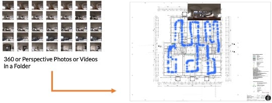
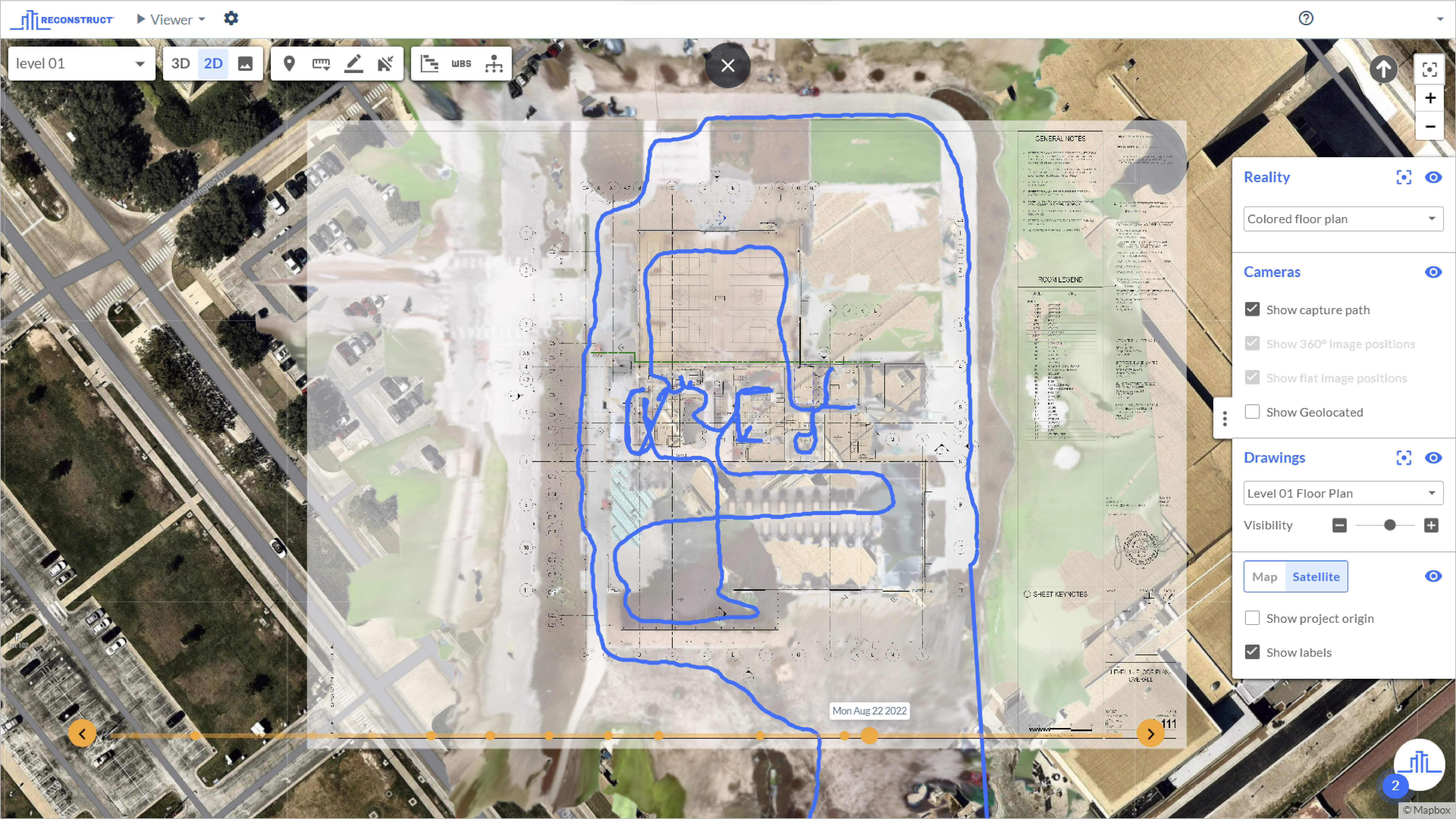
Above is a measurable, virtual site walkthrough in Reconstruct’s Visual Command Center. These models were automatically produced using only 360 video. No floor plan or design data was used to guide the process. You’ll also see a 2D reality floor plan in the lower left corner. Both these 2D floor plans and the virtual, 3D point clouds and mesh models are generated by Reconstruct’s reality mapping engine from the same 360 video input.
Key takeaways:
- Reality capture is the process of documenting a construction project by manually or automatically pinning images or video frames against a floor plan to create virtual documentation of a building or structure.
- Reality mapping takes reality capture several steps further by transforming standard and 360 photos and videos into a multidimensional, measurable, as-built version of a job site—all without needing to upload a floor plan as a starting point.
- Cutting-edge reality mapping capabilities—which separate Reconstruct from other reality-capture technologies—allow you to use photos and videos from a 360 camera, a smartphone, or a drone (not just an expensive laser scanner) to generate a truly immersive walkthrough of a job site, along with a 3D model and a 2D floor plan. Laser scanner and Matterport reality maps can also be imported, processed, and aligned against reality maps created from the photo and video-based reality capture data.
- This precise, mappable, digital twin replica of your project can save stakeholders time and money, improve coordination and communication between on-site and off-site teams, and allow every person on your team instant, remote access to every last detail of your job site, both as it stands today and as it appeared in the past.
What is reality capture?
In construction, reality capture is the process of documenting a construction project by automatically or manually pinning images or video frames against a floor plan. The outcome is an organized collection of images and video frames in space and over time that offer an accurate, digital representation of a physical asset's “as built” condition. Any building or structure can be photographed or videotaped: a residential high-rise, a new instructional facility at a university, an airport terminal, a tunnel, a bridge, a retail or restaurant space, and so on.
You do not need to invest in exorbitantly expensive equipment to benefit from reality capture. With Reconstruct, all the employees on your job site need is an affordable 360 camera and a smartphone to conduct a quick “capture walk.” Every time content is recorded, Reconstruct automatically pins those pictures and videos exactly where you’ve taken them against the true floor plan of your project and organizes them by date and time. The end result? A highly-accurate digital capture of your changing job site in space and over time.
Above, reality capture takes photos and videos from 360 cameras, smartphones, or drones and pins them, either manually or automatically, against uploaded floor plans.
What is reality mapping?
In construction, reality mapping supercharges “reality capture” into a genuinely mappable, measurable digital version of your as-built job site. Best of all, you don’t need to invest in expensive laser scanners for successful, day-to-day reality mapping—you can save laser scanning for when you really, truly need it. Unlike other solution providers, Reconstruct only needs images and video of your space captured by 360 cameras, smartphones, or a drone to create 3D point clouds and 3D mesh models and to automatically map floor plans and orthophotos of your construction site.
Above, reality mapping takes photos and videos from 360 cameras, smartphones, or drones and automatically transforms this data into floor plans, orthophotos, 3D point clouds, and 3D mesh models. Reconstruct’s reality mapping engine also automatically pins the source photos and video frames against reality floor plans and models.

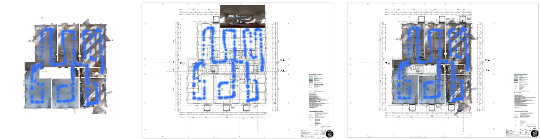
Above, Reconstruct’s reality mapping engine generates as-built floor plans while pinning 360 or standard images and videos against these plans. In the center, Reconstruct’s AI engine automatically aligns reality and design floor plans, allowing 360 or standard images and videos to be automatically mapped against a design floor plan. On the right, reality and design floor plans are twinned against one another, offering as-built vs. as-planned comparisons in 2D.
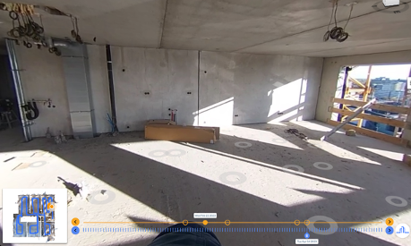
In other words, Reconstruct makes sense of your team’s recordings and automatically generates a measurable, time-lapsed, location-based, perfectly-organized reality capture of your construction site. With Reconstruct, anyone on your team can check in on the project, review progress, measure the space, and refer back to how the job site looked at a previous date or time.
Reconstruct can also consume laser scanning or Matterport capture data where and when you need high-precision or high-fidelity captures. Laser scanning and Matterport data can be imported and integrated with 3D point clouds, mesh models, and floor plans generated from videos and images taken with 360 cameras, smartphones, or drones.
Above is the equipment your team can use to collect reality capture data. Reconstruct’s reality mapping engine takes 360 and standard photos and videos from cameras, smartphones, and drones, transforming them into 2D reality floor plans and 3D point cloud data. It can also integrate this content with laser scanning and Matterport data, offering a consistent and measurable walkthrough experience, all within a single platform. Reconstruct is the only solution that supports all forms of reality capture data.
Once Reconstruct has consumed this data and mapped your space, your team receives instant access to a virtual, as-built model of your construction site. Most importantly, all this data is organized, managed, and accessible from the same online viewer. Any stakeholder—at any time, from anywhere in the world—can instantly visit Reconstruct’s Visual Command Center and explore, map, measure, or audit this as-built, digital twin replica and its associated floor plan, both as currently built and as it appeared in the past. Regardless of what equipment was used to capture the environment in the first place, Reconstruct generates a consistent, seamless walkthrough experience. As a result, project stakeholders don’t need to rely on multiple point solutions to separately manage data from 360 videos, drone images, and laser scanners.
Your team can also integrate these reality mapping data with 2D and 3D designs so that “as-built” models can be twinned against “as-planned” renderings. The result? A true digital twin model formed by overlaying design plans on top of reality mapping data.
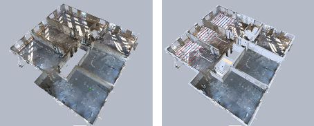
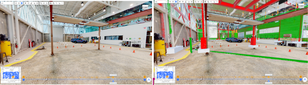
Above, Reconstruct’s reality mapping engine generates reality 3D point clouds and mesh models while pinning 360 or standard images and videos in 3D. On the right, reality and design 3D models are twinned against one another, offering as-built vs. as-planned comparisons for progress monitoring, quality control, inspections, and beyond.
What are the key benefits of reality mapping?
The top benefits of Reconstruct’s reality mapping technology include the ability to:
- Truly “walk through” a job site remotely—without the expense, exhaustion, inherent distraction, or time spend that comes with on-site visits.
- Accurately measure elements of your project in length, area, or volume.
- Review progress over time, even if your team did not take photos or videos from the same spot or you have different visual data sources.
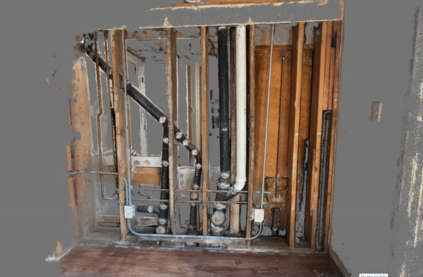
- Rewind to a previous time and date of your virtual asset to verify what’s hidden behind a wall, above a ceiling, or beneath the ground without the expense, hassle, or delay of demolition.
- Identify and investigate problems—then provide solutions before consequences snowball.
- Quickly and remotely provide vendors, employees, and partners with strategic, actionable insights.
- Maintain a measurable, precise digital twin replica of your building after construction ends to streamline building maintenance, renovation, and repairs, and address and resolve conflicts with tenants, inspectors, or future buyers.
- Twin your reality mapping data with 2D and 3D design data to easily compare “as-built” against “as-planned” conditions during construction.
- Update as-designed floor plans and models into as-built ones by reviewing changes during construction using reality mapping data and updating design plans and deliverables accordingly for final handover to clients.
- Retain truly accurate, as-built, reality-mapped records of your finished project for years to come, and rely on those files for operations, maintenance, inspections, and more throughout the structure’s lifecycle.
- Protect yourself from liability issues and litigation by maintaining proof of work over the construction timeline, including evidence of what’s where and what’s below, beneath, or between floors, ceilings, and walls.
At Reconstruct, we know that most construction stakeholders are visual people, regardless of their jobs. Our reality mapping technology creates a precise, measurable digital version of your construction project over time, allowing each team member to coordinate and communicate their work on the project, both at a highly-detailed level and from a broader, more zoomed-out view.
Learn how Reality Mapping can help your next project.
Get your demo today!
Related Posts
Geo-Referenced Reality Capture for Construction Stakeholders
For geo-referenced reality capture of construction projects, the right reality mapping engine can now align 360 and smartphone footage to satellite maps.
Smartphones for 3D Reality Mapping in Construction
Smartphones are an easy, reliable way to capture construction details for 3D reality mapping and site surveys.
How to generate 3D point clouds from both 360 and drone reality capture
Blend indoor 360 video capture and outdoor drone capture for one integrated 3D reality mapping system.