Measurability and Construction Reality Mapping
When it comes to reality mapping, many stakeholders across the construction, inspection, and engineering industries utilize a digital twin of the job site to perform various tasks, including measuring certain aspects of the construction site or completed structures.
Previously, such measurability was only achievable through reality data captured via laser scanning. However, with the development of Reconstruct’s cutting-edge reality mapping technology, it is now possible for stakeholders to achieve measurability using inexpensive and quick-to-capture footage from a 360 camera and other devices, like a smartphone or drone.
In this article, we will zero in on how measurability is achieved in digital twins and in which scenarios stakeholders may benefit from measuring a digital twin.
Measurability and digital twins for construction
Different types of construction reality data enable measurability. Some types of data are already measurable. Such data includes the point clouds derived from laser scanning. Examples of already measurable data include a third-party generated point cloud, a mesh model, and a BIM model. These assets “arrive” measurable and can be viewed and inspected within Reconstruct (or another platform) as is.
What's unique about Reconstruct’s photogrammetry engine is that it creates measurable point clouds captured on easy-to-use, inexpensive equipment that, in the past, could only “capture footage” but not truly “map” it so it could be measured. What’s more, Reconstruct can interpret and blend data from all of these devices, allowing users to select the best (or best-available) tool they have given unique personnel, time, and budget constraints.
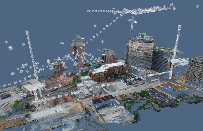
More specifically, Reconstruct can interpret images and videos from any source, including 360 cameras, smartphones, and drones. The raw footage captured on these devices is two-dimensional. What Reconstruct’s system does is build a 3D model out of those images--one that will, quite rapidly, turn into a measurable point cloud.
Here’s how it works: The photogrammetry engine begins interpreting and sorting these images, finding relationships between them, and connecting the dots. Once this process is complete, Reconstruct begins to perform localization. This refers to the process during which our reality mapping technology determines where the camera was located when the footage was captured. This process continues for all remaining picture and video frames.
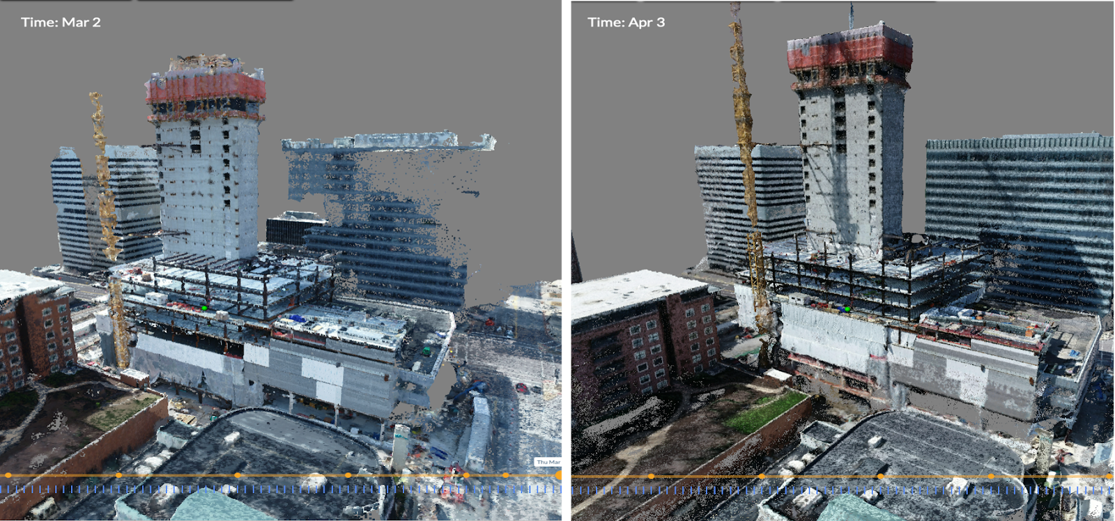
When this work is complete, Reconstruct has put together what we call “sparse reconstruction.” This is, in effect, a very light point cloud with localization information attached to it.
This is a seed for the next step, which is called “dense reconstruction.” At this point, because the computer now knows the location of these light point clouds, a more complex and even more accurate analysis of footage begins. Using various cutting-edge technologies and algorithms, our reality mapping engine begins to put together a “dense reconstruction" that is so tightly clustered it nearly resembles laser scanning footage.
Without the need to import third-party mesh models or BIM or perform expensive and time-consuming laser scanning, stakeholders can create a measurable point cloud of construction or a completed asset or infrastructure using everyday and affordable devices operated by personnel already on the job site.
Reconstruct also generates a mesh model alongside the point cloud. As-built 2D floor plans are also provided automatically.
Related: Reality Mapping Vs. Reality Capture: What’s the Difference?
How stakeholders use reality mapping to measure construction
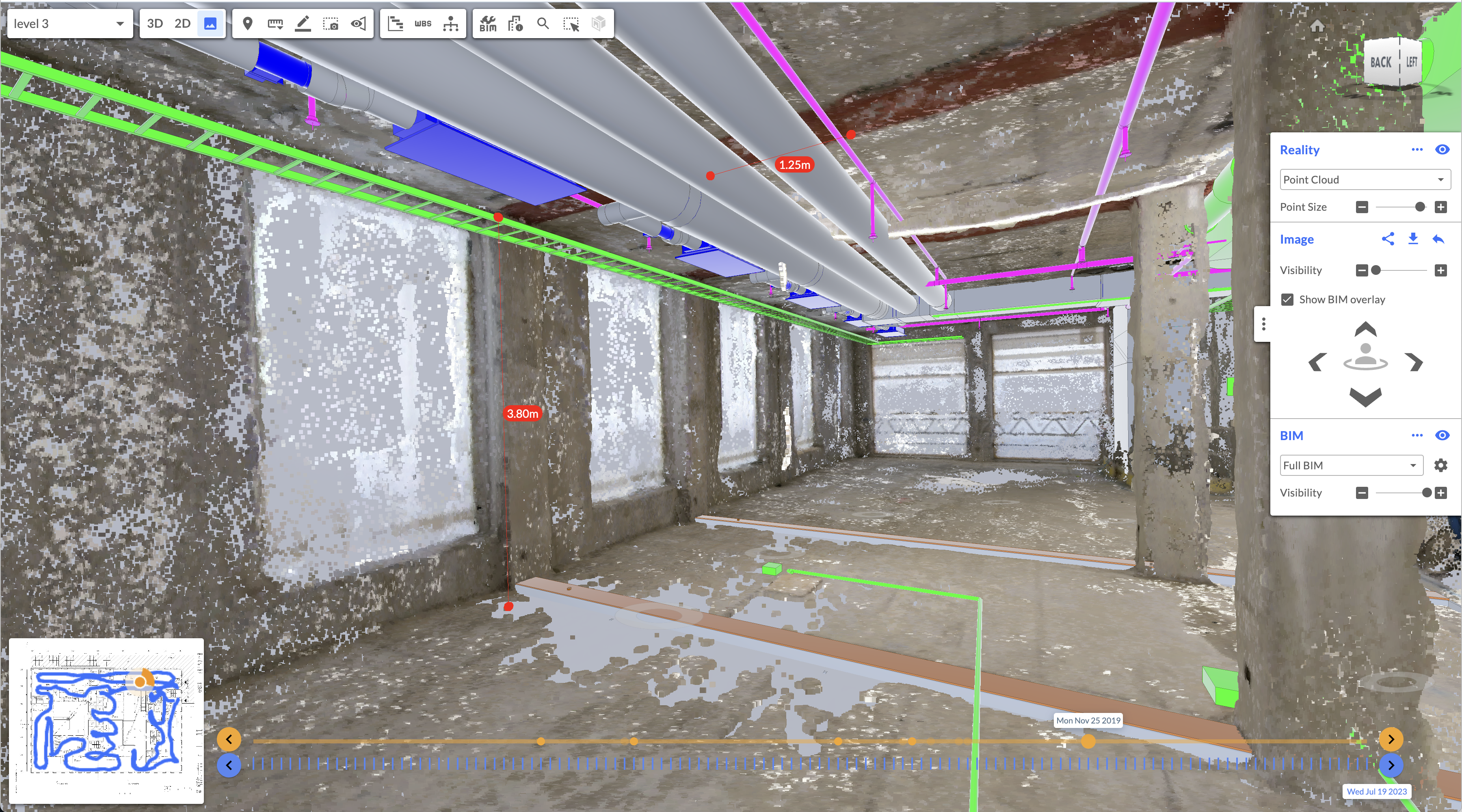
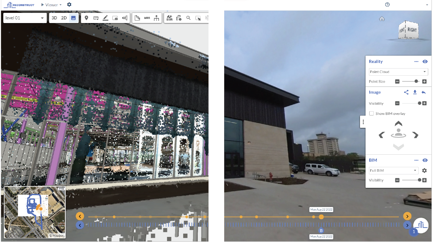
Once construction, inspection, and engineering stakeholders have allowed the reality mapping engine to transform data into a measurable point cloud or mesh model, these stakeholders can use the digital twin to measure virtually any aspect of the job site without needing to travel to the construction zone.
At present, virtually every Reconstruct customer utilizes the measurement features offered. Rapidly “grabbing” site measurements is an essential component of remote project monitoring and inspection, remote construction quality control, remote payment application verifications, and virtually anything else a stakeholder might have once traveled to the job site to do with a measuring tape.
This includes, amongst other use cases, preparing for future renovations, tenant improvements, or even overlaying plans against reality data to see just how far off an installation mistake might be. Other times, stakeholders may use the digital twin during facility condition assessments. This may mean measuring cracks on the sidewalk or determining whether there's enough clearance at an exit to meet updated safety rules and regulations.
Regarding payment applications, measurements can help owners' representatives verify that work was completed as promised and quoted. For example, if such a stakeholder was trying to determine how many tiles had been installed, that stakeholder could measure the dimensions of the walls and perform the right calculations to verify how many square feet of tile were used. The same goes for determining whether fixtures and installations were installed in exactly the right place before payments are approved.
Another example: Early on in projects, measuring digital twins can assist with dirt digging and excavation. It allows stakeholders to measure how much dirt needs to be moved and how much has already been moved. These are volume measurements, and many Reconstruct users rely on them at the beginning of a construction project.
The ability for remote stakeholders to inspect and measure a job site without the resource burn of travel is a huge time and cash savings opportunity for most organizations. After all, an architect, inspector, or engineer can now review and measure multiple job sites from their desk in a single afternoon—responsibilities that, should they have needed to be performed in person, may have taken weeks to complete and cost the organization tens of thousands of dollars, if not more.
About Reconstruct
Reconstruct is a cutting-edge provider of reality mapping technology. Our digital twins have set the standard for accuracy and measurability across the construction, inspection, and engineering industries. No other reality mapping provider allows customers to blend footage from any and all capture devices, including smartphones, 360 cameras, drones, laser scanners, and more.
Whether you use laser scanning, mesh models, or BIM to measure your job site remotely, the addition of rapidly and inexpensively captured reality data can unlock a whole host of benefits for your organization throughout the construction process and beyond.
To see your project as a measurable digital twin, schedule a free demo today.