
Drones for construction reality mapping 101
Over the past few months, we’ve zeroed in on the main benefits of geo-referenced reality capture with smartphones and 360 cameras. In this article, we’ll introduce a third device Reconstruct users often utilize for reality mapping and creating a digital twin for construction: the drone.
We’ll focus on what a drone is, what kind of reality capture it’s the ideal device for, who can operate it, and how using a drone alongside other devices can help your organization create photorealistic, virtual duplications of your construction site, structure, or infrastructure.
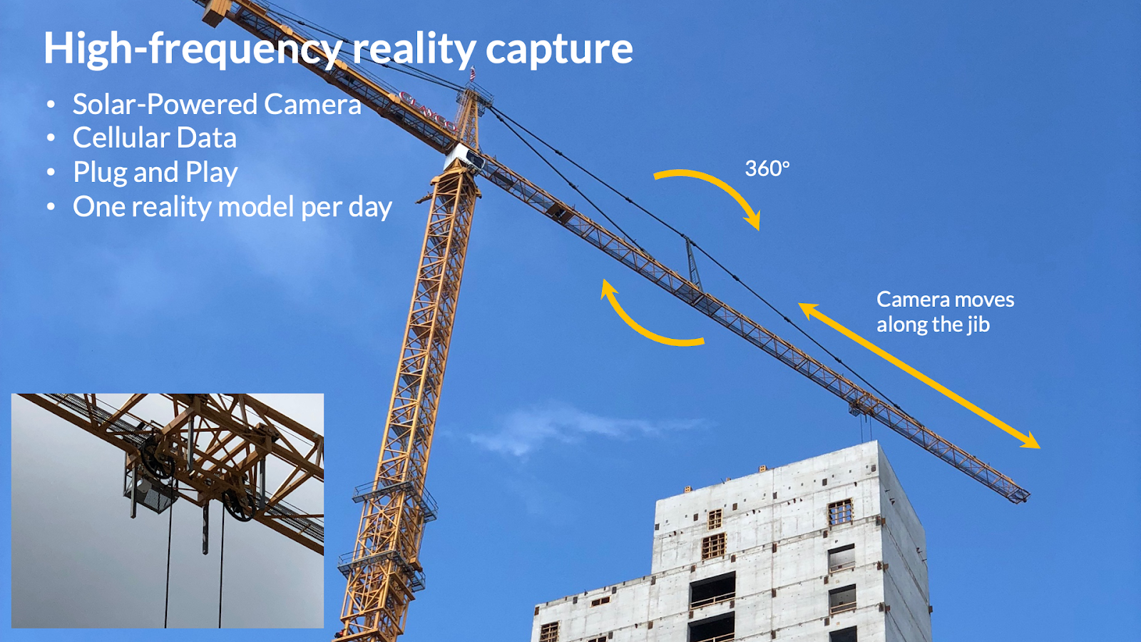
We’ll also touch on how Reconstruct can blend any drone footage with reality data captured with any other device, including a smartphone, a 360 camera, or a Matterport or laser scanner, to create one digital twin of your job site in space and over time. We’ll also discuss how Reconstruct helps its customers get the data, measurability, and insights they need via drone capture by assisting with permits, partnering with third-party drone pilots, and pioneering technology in which time-lapse cameras from our partner, Sensera, are fastened to cranes, enabling drone-style reality capture in restricted flight zones often found in dense urban areas.
Key takeaways
- A drone is an unmanned aircraft that can capture visual information about virtually anything, including the current conditions of a construction project, structure, or infrastructure.
- Drones are perfect for capturing high-resolution footage of vast spaces, including building exteriors, roads, towers, and bridges. They’re also great for interiors of large spaces, like stadiums and data centers. The most appealing benefits of drones include reducing the cost of aerial photography with high frequency drone captures particularly for larger areas, and reducing the on-site costs and improving the safety of engineers and superintendents during inspection of hard-to-reach areas.
- Limitations of drones include wind and needing to capture data within some (but not all) enclosed spaces. FAA regulations also restrict who can operate drones over a certain weight and in what areas, although lightweight drones, tethered drones, and Reconstruct’s crane-operated solutions enable more stakeholders to reap the benefits of drone-captured reality mapping.
- Drone footage can be blended with reality data captured via any other device in Reconstruct’s reality mapping engine, automatically creating a timestamped digital twin.
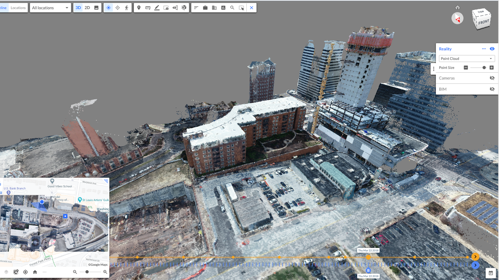
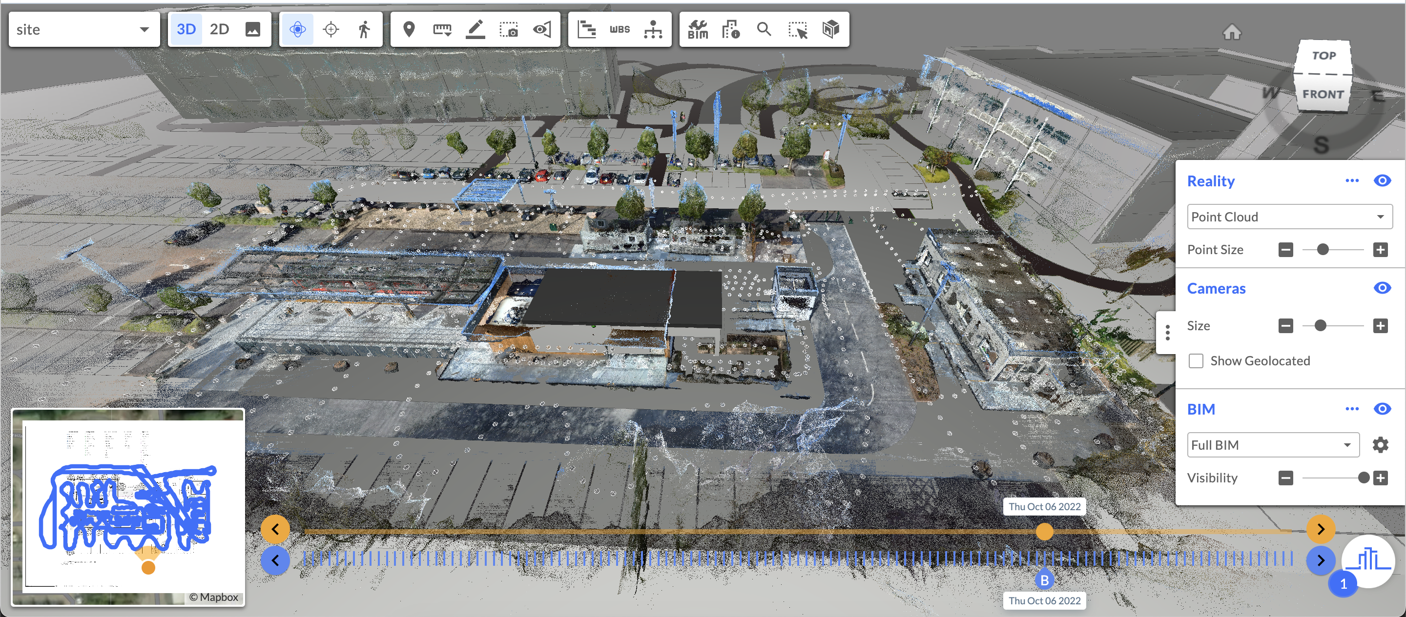
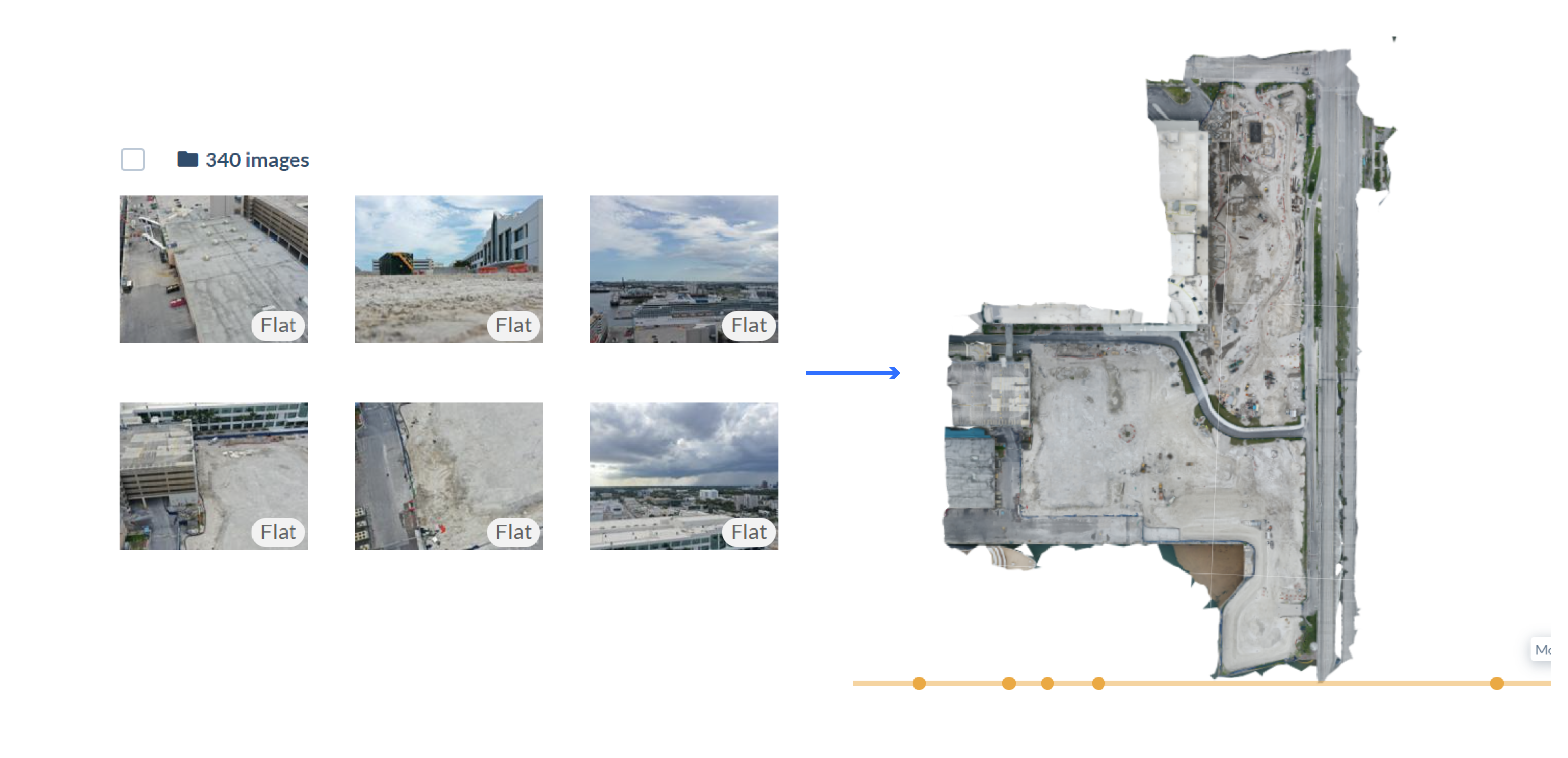
Reconstruct engine automatically created point clouds, mesh models, and 2D orthophotos from drone images and represents this data in one integrated environment.

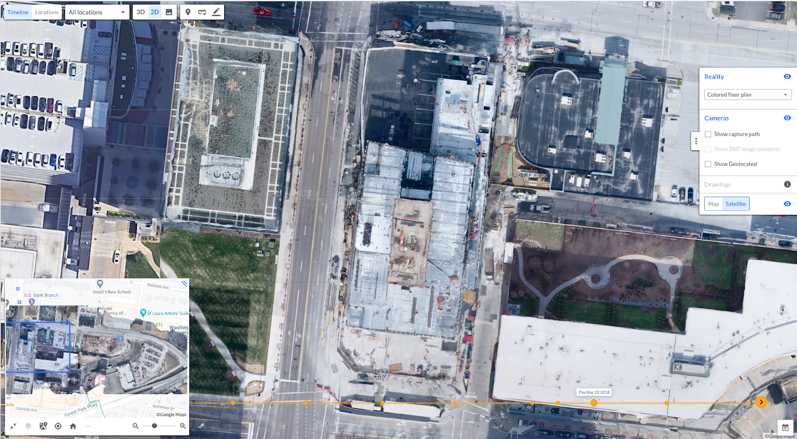
High-quality orthophotos are generated for drone images and are overlaid against a map. These measurable models can be downloaded from Reconstruct and used as a basis of design in other 2D and 3D model authoring environments.
How are drones used for reality capture?
A camera-equipped drone, at least as a reality capture device, is quite similar to the smartphone in that it produces a large collection of overlapping high-resolution images. The key benefit of a drone, of course, is that it can autonomously or semi-autonomously fly and take overlapping images that can guarantee the success of a 3D reality mapping engine. Users can launch the device anywhere within a 3D space, and autonomously execute a flight mission to capture images when and where needed.
In other words, a drone can complete reality capture while the user stays safely planted on the ground, exploring all those hard-to-reach, way-too-high, and not-so-safe aspects of the job site without all the risks to personnel. The drone also captures vast areas very quickly. The drone is an excellent device for widespread geo-referenced reality capture, especially in large outdoor areas.
Drones are perfect for capturing not only the exterior of skyscrapers but also horizontal assets like data centers. They’re also great for capturing roads and airport runways—anything that would benefit from the lens of a device that can fly.
Still, the drone has its limitations. Mostly, the device is only useful so long as it has a large amount of sky to fly through. That means, in many cases, once the envelope of a building is completed, a drone can only be used for exterior capture. Of course, there are exceptions, like massive factories and stadiums--and more modern, autonomous solutions such as Skydio have shown that when appropriately dispatched, drones can reliably operate indoors.
Learn more about what tools are best for what types of reality capture in our experiment with Oracle here.
One other limitation is wind. Gusts over 30 miles per hour are enough to end drone capture until conditions change.
.
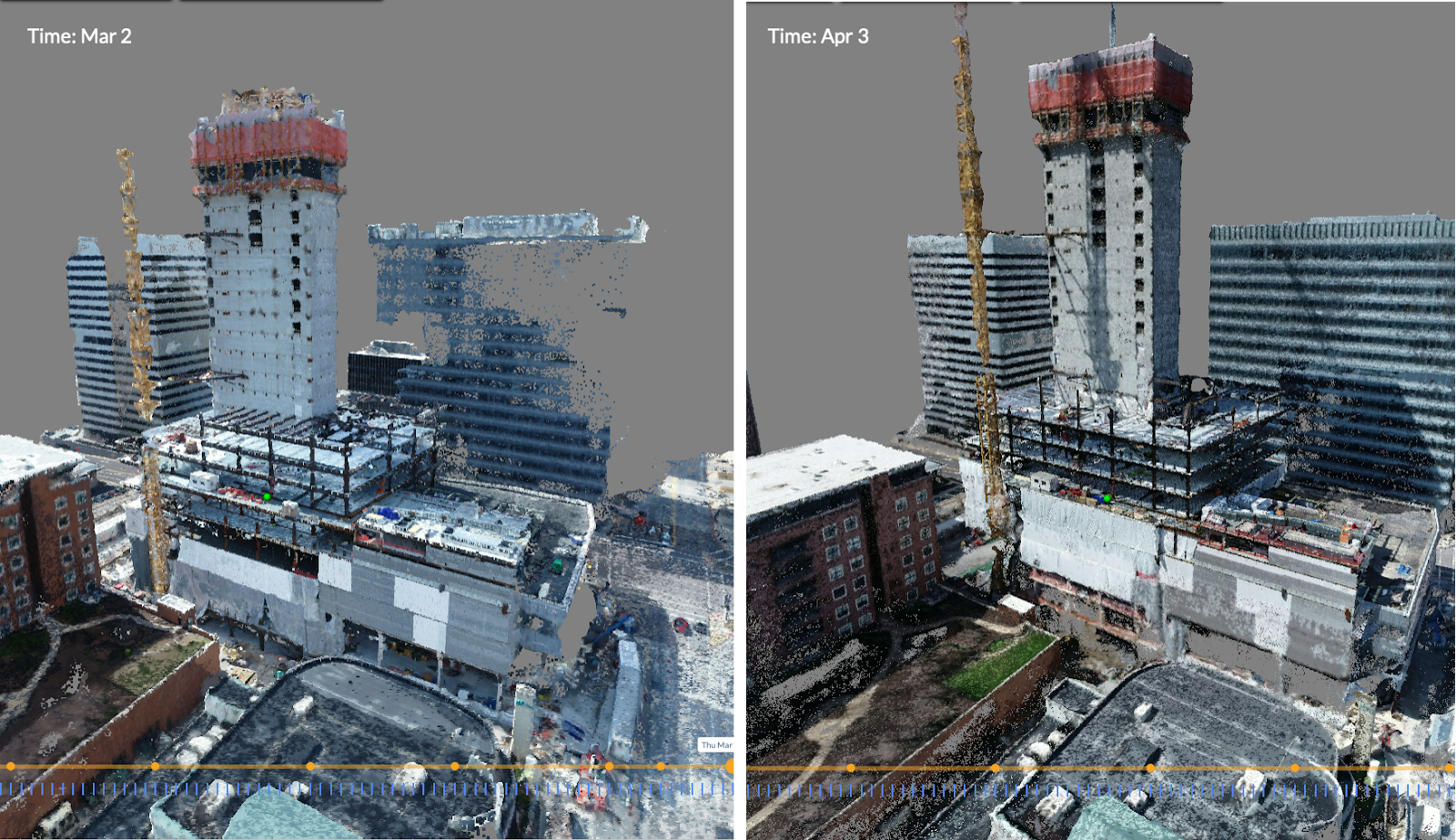
Reconstruct engine generates a time machine for construction using reality capture over the project timeline. The image on the left shows a reality capture on March 2, and the image on the right shows a reality model on April 3. Reality models are automatically created and mapped in 3D using drone data and are automatically aligned against one another using AI-based advanced computer vision capabilities.

Crane camera images can be used to automatically generate 3D point clouds, 3D mesh models, and 2D orthophotos that are measurable. These deliverables can be used for quality assurance and quality control, with or without using BIM and/or 2D design drawings as overlays.
Who can operate a drone for construction reality capture?
Typically, drones are operated by general contractors or other key stakeholders who understand how to use the equipment and exactly what data that equipment needs to collect. Reconstruct assists organizations interested in receiving permits and training to operate drones. For those who’d rather gather insights without the training and permitting, Reconstruct can partner stakeholders with trusted drone pilots ready to capture whatever data they need at whatever frequency they decide.
If you choose to operate a drone internally, you must follow all FAA regulations. So, who, exactly, can operate a drone? The law is clear: you cannot fly a drone for commercial use cases without a license. The law defines a drone as a device that weighs 250 grams or more, which is about half a pound.
FAA also restricts flying a drone within a five-mile radius of an airport or helipad. When needed, such flights require specific permits which take time to procure from the FAA. Reconstruct can assist with this process.
How Reconstruct uses drone footage
Reconstruct uses drone footage to rapidly build maps and models of your job site that are measurable, data-rich digital twins of your project as it is currently constructed. Whether you already use drones for reality capture or are considering adding them to your arsenal, Reconstruct stands out from other reality mapping engines for its ability to automatically blend all footage captured from any device, instantly creating one timestamped digital twin of your job site throughout construction.
This is essential because, with Reconstruct, stakeholders can leverage exterior drone footage alongside panoramic images and videos captured via 360 cameras and high-resolution, detailed pictures captured via smartphone and even laser scanner.
Once a digital twin has been generated, these reality models can be used for visual progress monitoring, visual quality assurance and quality control, comparing what’s there vs. what should be there, facility condition assessments, physical asset inspections, site surveys, construction risk management, 4D planning and 4D scheduling, the creation of online as-builts, and look-ahead scheduling.
One Reconstruct customer saved $30K on a single excavation project, thanks to digital twin-enhanced payment applications. Another Reconstruct user leaned on reality data capture via drone to improve quality control and enhance project visibility, ultimately avoiding $17,000 in concrete rework. For more information on capturing the reality of your next project with a drone or help choosing the right tools and resources for creating a digital twin of your job site, feel free to contact us for a demo.

Drone images and their associated orthophotos are geo-registered and twinned against design allowing as-planned conditions to be easily compared against as-built conditions.

2D orthophoto is automatically generated using Reconstruct’s reality mapping engine from a collection of overlapping images taken with a drone. This geo-registered reality map is twinned against 2D CAD.
Related Posts
.png)
How to generate 3D point clouds from both 360 and drone reality capture
Blend indoor 360 video capture and outdoor drone capture for one integrated 3D reality mapping system.
Benefits of 3D Scanning in Construction
The benefits of 3D scanning in construction include improved remote quality control, virtual progress monitoring, and protection against liability claims.
How Reality Capture & Mapping Forms a Digital Twin for Construction
How reality capture and modern reality mapping technology enable the formation of a digital twin for construction without the need for laser scanning.